MOTOSHARE 🚗🏍️
Rent Bikes & Cars Directly from Owners
Motoshare connects vehicle owners with people who need bikes and cars on rent. Owners earn from idle vehicles, and renters get flexible ride options.
Visit MotoshareIntroduction
Karnataka, a vibrant state in southern India, is known for its rich cultural heritage, technological advancements, and diverse demographic composition. With a population exceeding 67 million (as per the 2021 census estimates), Karnataka ranks among the top states in terms of economic and human development. This blog provides an in-depth look into the demographic profile of Karnataka, covering aspects such as population growth, density, literacy rate, urbanization, and cultural diversity.
Population Growth and Distribution
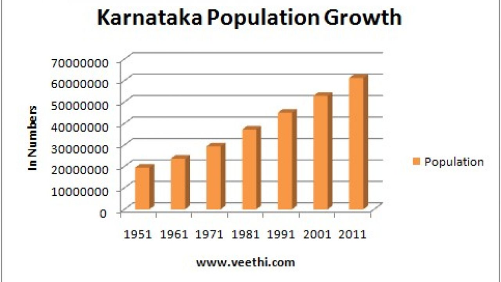
Karnataka has witnessed significant demographic changes over the years. The state’s population growth rate has slowed compared to previous decades, reflecting national trends toward stabilization.
| Year | Population (millions) | Growth Rate (%) |
|---|---|---|
| 1951 | 19.4 | – |
| 1961 | 23.6 | 21.6 |
| 1971 | 29.3 | 24.2 |
| 1981 | 37.1 | 26.6 |
| 1991 | 44.8 | 20.7 |
| 2001 | 52.8 | 17.9 |
| 2011 | 61.1 | 15.7 |
| 2021* | 67.5 | 10.5 |
(*Estimated figures based on projections)
The population is unevenly distributed, with urban centers like Bengaluru, Mysuru, and Hubballi-Dharwad experiencing rapid growth, while rural areas have seen moderate increases.
Population Density
Karnataka has an average population density of 319 persons per square kilometer. The density is significantly higher in cities such as Bengaluru, which has over 4,400 people per square kilometer, while districts like Kodagu and Uttara Kannada have much lower densities.
Urbanization Trends
Urbanization has been a key feature of Karnataka’s demographic landscape. The state has a robust urban population, driven largely by IT and industrial growth in Bengaluru, which alone contributes to more than 40% of the state’s urban population.
| Category | Urban (%) | Rural (%) |
| 1961 | 23.1 | 76.9 |
| 1991 | 31.2 | 68.8 |
| 2011 | 38.7 | 61.3 |
| 2021* | 45.2 | 54.8 |
(*Projected values)
Urban centers such as Bengaluru, Mysuru, Mangaluru, Hubballi, and Belagavi have played a vital role in driving economic growth and migration.
Literacy Rate
Karnataka has made remarkable progress in education, with a literacy rate of 75.4% as per the 2011 census. The estimated literacy rate for 2021 is 81.2%, showcasing significant improvements in both male and female literacy.
| Gender | 2011 Census (%) | 2021 Estimated (%) |
| Male | 82.5 | 86.4 |
| Female | 68.1 | 76.3 |
Efforts in improving school enrollment, digital education initiatives, and adult literacy programs have contributed to this growth.
Linguistic and Religious Diversity
Karnataka is home to multiple linguistic and religious communities, fostering a rich cultural tapestry.
Languages Spoken
- Kannada (Official Language, spoken by ~66%)
- Urdu (~10%)
- Telugu (~6.5%)
- Tamil (~5.5%)
- Marathi (~3.5%)
- Tulu, Konkani, and Malayalam also have significant speakers in coastal areas.
Religious Composition
| Religion | Percentage (%) |
| Hindu | 84.0 |
| Muslim | 12.9 |
| Christian | 1.9 |
| Others | 1.2 |
Religious harmony and festivals like Dasara, Ugadi, Deepavali, Eid, and Christmas reflect Karnataka’s diverse social fabric.
Workforce and Economy
Karnataka is an economic powerhouse, leading in IT, agriculture, and manufacturing. Bengaluru, known as the Silicon Valley of India, attracts skilled professionals, contributing to migration and demographic shifts.
| Sector | Contribution to State GDP (%) |
| Services | 66.2 |
| Industry | 24.1 |
| Agriculture | 9.7 |
Conclusion
The demographic evolution of Karnataka highlights its rapid urbanization, literacy improvements, and economic growth. While Bengaluru drives much of the state’s progress, efforts to bridge the urban-rural divide and preserve cultural diversity remain crucial for sustainable development. Karnataka continues to be a dynamic and thriving state, poised for further advancements in the coming decades.
I am a passionate traveler, city explorer, and digital publisher focused on documenting real journeys, local cultures, and everyday travel experiences across India and beyond. Through my platforms, I share practical travel guides, city blogs, and daily travel logs that help readers explore destinations with confidence and local insight.
I am the creator of HolidayLandmark, a travel-focused ecosystem covering destinations, stories, and experiences through blogs, social platforms, and curated travel content:
- Instagram – HolidayLandmark
- Facebook – HolidayLandmark
- YouTube – HolidayLandmark
- LinkedIn – HolidayLandmark
- X (Twitter) – HolidayLandmark
- HolidayLandmark on Blogger
- HolidayLandmark on WordPress
- HolidayLandmark Stories
Alongside HolidayLandmark, I manage multiple city-focused travel portals where I publish daily travel logs and in-depth city blogs covering local attractions, food, culture, and real traveler experiences:
City Daily Travel Logs
- Bangalore Orbit – Daily Logs
- Bhopal Orbit – Daily Logs
- Chennai Orbit – Daily Logs
- Gujarat Orbit – Daily Logs
- Kerala Orbit – Daily Logs
- Mera Apna Bihar – Daily Logs
- Mumbai Orbit – Daily Logs
City Blogs & Travel Guides
- Bangalore Orbit – Blog
- Bhopal Orbit – Blog
- Chennai Orbit – Blog
- Gujarat Orbit – Blog
- Kerala Orbit – Blog
- Mera Apna Bihar – Blog
- Mumbai Orbit – Blog
Through these platforms, my goal is to create a connected travel network that offers reliable city information, real-time travel experiences, and practical guidance for travelers, explorers, and local enthusiasts.