Sudhagad
The origin of this fort is said to date back to the 2nd century B.C the same age as the Thanale and Khadsamble caves nearby. It was then called Bhrorapgad (after its presiding deity, Bhoraidevi). In 1436, it was captured by the Bahamani Sultan. In 1657, the Marathas took over and renamed it "Sudhagad"(the sweet one). It was a large fort and Sudhagad was considered by Shivaji as the capital of his kingdom. He surveyed it, but instead chose Raigad because of its central location.
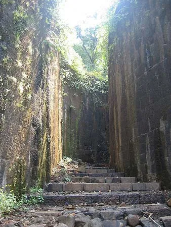
About Sudhagad
Sudhagad is one of the rarely visited forts in Konkan region. It is amongst those few forts in Maharashtra which are still in good condition. The management of this fort was handled by the king of Bhor. The outside wall of the fort is a strong one and still in good shape. The fort is 2000 feet high. The fort lies near Pali - one of the famous Ashtavinayakas.
The way to Sudhagad is from Village ’ Bairampada ’ - 13 Kms west to Pali. There are 3 doors to the fort. One of them is ’ Maha Darwaja ’ . This is very huge door but still in good state. A big platue on the fort consists of temple of Lord Shiva and ‘Ambar Khana’ (Where the elephants were kept). The main temple of the fort is of ‘Devi Bhorai’. The other spots on the fort are a small pond, Echo Point and Takmak Tok. Sudhagad is one of the vital forts in Konkan region. It can be covered while a trip to Pali and Mahad in Ashtavinayak.
In the regime of the Peshwas, the ‘Pantsachivas’ of Bhor became the custodians of this fort. After the annexation of princely states in 1950 the fort became patron less. As a result, the fort is in a state of ruins, even though it escaped the wrath of the British.
Regarded as one of the oldest forts in Maharashtra, Sudhagad, or Bhorapgad as it used to be called before Shivaji conquered it, dates back to a time Before Christ. A few Puranas claim that Sage Bhrug stayed here built the temple of goddess Bhorai. It was used as a strategic vantage point by the rulers of the Bhor dynasty and was later annexed by the Bahamani Sultan in the 1400s.
History
The ‘Thanale’ excavations in this area are nearly 2200 years old. This shows that Sudhagad may be that much ancient. The construction and the geographical significance indicate that some great rulers might have constructed the fort.
According to the Puranas, Sage ‘Bhrugu’ had stayed here and he had established the temple of Goddess ‘Bhorai’ on this fort.
Sudhagad was included in ‘Swarajya’ in 1648. It is described in old records as follows:
“Malavji Naik Karake put the ladders in Sakharadara. Initially, Jadhav and Saranayak both climbed the fort under the guidance of chieftain ‘Maloji Bhosale’. After that Haibatrao climbed the fort. 25 soldiers went ahead and killed the guards. Further the chief of the fort was killed in anguish and the fort was conquered.”
Shivaji Maharaj renamed Bhorapgad as Sudhagad. Later Sambhaji met Akbar (the rebellious son of Aurangjeb) in the ‘Pachchapur village’ situated at the base of this fort. Annaji Datto, Balaji Aavji Chitnis, his son Aavji Ballal and Hiroji Pharjand were all important persons in ‘Ashta-Pradhan Mandal’ of Shivaji Maharaj. Sambhaji has killed all of them in ‘Parli’ village near Sudhagad.
Interesting things to do
Trekking is the most interesting thing to do for ppl here.Photographers delight.
Interesting things to Visit
Bhoreshwar temple :
There is temple of ‘Bhoreshwar’ near the palace. If we move further, we can see a well with a secret door. There are steps from palace to the ‘Bhorai Devi’ temple. If we descend towards the other route, it takes us to water cisterns, which hold good drinking water. The route on the left side of these cisterns takes us towards a secret door. But this route doesn’t exist now.
Pachchapur Darwaaja :
If we enter to the hill through this door, we come across a plateau after climbing some distance. To the left is the temple of ‘Siddheshwar’, storehouses of food grains, some cisterns, a lake named “Hawaldar Tale” and “Hattimaal”.
On the right hand side we can see natural fortification of the fort.
Takmak Tok of Sudhagad :
After leaving the palace come up with the steps and turn to right hand side of the route. This route goes through ‘Hatti Paga’ (place where elephants were tied).It directly takes us to one peak. This peak is very similar to the cliff “Takmak Tok” on Raigad. From this peak Dhangad, Korigad, Tel-Baila can be seen very clearly. Similarly river ‘Amba’ and the villages surrounding it can be seen from this place.
Dindi Darwaaja :
The way from Ghat of Sawashni takes us directly to Dindi Darwaaja. This door is exact replica of the ‘Mahadarwaaja’ (main entrance) on Raigad. The construction and arrangement of this door is of the type called “Gomukhi” (in shape of cow’s mouth). This door is well protected since it is hidden in between two huge bastions.
There is one secret path well on the fort at the backside of the palace.
It has one tunnel in it, but now it is dumped by mud. There is also a secret path to move down from fort in case of any difficulty. There are some tombs at the backside of the Bhorai Devi temple. We can find beautiful carvings on them.
Hotels/Lodge/Accommodation
- Kamath Residency # 9324306203
- Govt. Rest House, Pali.02145-222167.
Help Line/Phone Number
The Kundalika is a small river flowing from the Hills of Sahyadri to the Arabian Sea. This river originates at a small town called Bhira in the Indian State of Maharashtra, 150 km south east of Bombay (Mumbai). The important towns located on the banks of Kundalika are Kolad, Roha and Salav.River Kundalika is fed by the excess water from Tata Power’s Mulshi Dam Project on to a series of hydroelectric projects and dams, including Ravalje followed by Bhira and then Dholvan, where the water is released in the morning typically at 6 am…..more
River Vashishti is one of the larger rivers in the Konkan coast of Maharashtra, India. The town of Chiplun lies on its banks. The river begins in the Western Ghats and snakes its way westwards towards the Arabian Sea. Kolkiwadi Dam, near Alore has a vast reservoir which feeds a tributary of the river. During the 2005 Maharashtra floods, the river swelled its banks, causing many of the city’s residents to evacuate it……more
Alibag or Alibaug is a coastal town and a municipal council in Raigad District in the Konkan region of Maharashtra, India. It is headquarters of the Raigad district.Alibag (also called Alibagh or Alibaugh) is an idyllic, peaceful town on the western coast of India (which is known as the Konkan region). It lies on almost the same latitude as the southern tip of Mumbai and is very close to this tip across the narrow strip of the Arabian Sea, conquerable by a ferry…..more
Shriwardhan-Harihareshwar Beach is the two unexplored beaches on the Konkan coastline. If you are an adventurous person and die on seafood delicacies, Shriwardhan Beach is the place where you should be.The water is inviting and can be explored on a boat, sailing deep into the sea, cutting through the gentle winds. A small adventurous boat ride will take you to a place where Peshwas originally resided. Shriwardhan-Harihareshwar Beach is about 200km from Mumbai……more
Padmadurg is a fort in Maharashtra, India. It was built by shivaji to northwest of Janjira. Although it is not as big as Janjira but still a sea fort that can be visited and enjoyed.Spread over a vast area of about 9 acres, Padmadurg Fort is regarded as one among the major sea forts in India. A monument of great historical importance, it is situated in Raigad District of Maharashtra. This famous fort is constructed by the great Marathas in order to conquer the Janjira Fort which lies near by……more
Karnala is 120 km from Pune and 13 km from Panvel. Between Pune and Panvel lies the Fort Karnala.Just 10 km off the busy Mumbai-Pune highway a sign welcomes visitors to the Karnala Bird Sanctuary. As the road winds up a little ghat on Mumbai-Goa highway, travel-weary visitors feel a sudden freshness in the air as they enter this pocket-sized Eden…..more
Copyright 2016 HolidayLandmark All rights reserved
Location info
-
Address:13 Kms west to Pali
-
District: Raigad
-
Nearest City: Raigad
-
Best time to visit: Any Time
Climate & weather
Like most of the other forts in the region, the temperature is always a few degree lesser than the plains. Summers are harsh and winters and rains are the most favorable times to visit the fort. Monsoons range from June to August, while winters stretch from September to February.
How to reach Sudhagad
-
Nearest Railway Station:The Konkan railway route has a halt at Nagothane. A train ride from Mumbai would be ideal and wont
-
Nearest Airport:Mumbai International Airport.
-
**Road Transport: Sudhagad is 118 Kms from Mumbai and 123 Kms from Pune/Lots of buses leave from both Pune and Mumbai for Pali
**
Things to carry
Trekkers carry your usual fare that includes, rope, first aid kit etc. unless you are traveling in the peak summer, you need not carry portable water, because it is available on the fort in cisterns most times of the year. Please do get a pair of binoculars along. You would also need to carry some food along, although a few people do reside on the fort and can provide you with meals, its best not to bank completely on them.
Best time to visit Sudhagad
October to March: cool and pleasant weather ideal for trekking. Avoid monsoon (June–September) as trails become slippery and dangerous.
Timings & opening hours
Typically open from 6:00 AM to 6:00 PM daily. Some forts may close earlier during monsoon or for maintenance.
Entry fee & tickets
Free entry for most hill forts. ASI-protected forts may charge INR 25 for Indians and INR 300 for foreign nationals.
Duration needed
3–4 hours including trek to the top and exploration. Larger forts may require a full day.
Safety tips
Wear sturdy footwear with good grip. Carry sufficient water — many forts have no water sources on top. Do not climb on unstable walls or edges. Start the trek early in the morning to avoid afternoon heat. Inform someone about your trek plan.
Nearby visiting places
Nearby forts in the same range, nearby hill stations, temples, and viewpoints. Other attractions within 10–30 km.
Nearest airport, railway & bus
Nearest airport: Pune International Airport (PNQ) or Mumbai International Airport (BOM). Nearest railway station: Pune Railway Station or nearest station on the Central Railway. Well-connected by road from Pune and Mumbai.
Mobile network coverage
Airtel, Jio, and Vi all provide excellent coverage across Maharashtra’s cities (Mumbai, Pune, Nagpur) and major tourist areas. 4G is reliable along highways and in most towns. Coverage may be weaker in deep forest areas of Tadoba, Melghat, and certain ghat sections. Free Wi-Fi is widely available in hotels and cafes.
Food & restaurants nearby
Most hill forts in Maharashtra have local snack stalls at the base serving pithla bhakri, vada pav, and tea. Carry food for longer treks — many forts on hilltops have no facilities. The nearest village or town offers Maharashtrian thali meals.
Nearest petrol pump
Petrol pumps are available in the nearest town or on the approach road to Sudhagad. It is advisable to fill fuel before heading to remote areas, especially hill forts and wildlife sanctuaries.
Frequently asked questions
How long does it take to trek to the top? The trek to most forts takes 1–3 hours depending on the fort’s height and the trail condition. Some forts have road access up to the entrance.
Is there food and water available on the fort? Most forts have no facilities on top. Carry at least 2 litres of water per person and some snacks. Local stalls at the base village sell refreshments.
Can I visit during monsoon? Many forts are open year-round but trails become extremely slippery during monsoon. November to February offers the best trekking conditions.
Quick facts
- Location: Maharashtra
- Best time to visit: October to March for comfortable exploration
- Ideal duration: 1-2 hours to explore the site
- Entry: Nominal entry fee at most ASI-protected sites
- Photography: Allowed at most sites; videography may require permit
Map & location view
- Destination: Sudhagad
- State: Maharashtra, India
- Region: historical region of Maharashtra
- How to reach: Accessible by road from nearby towns and cities. Local transport options include buses and taxis.
- Google Maps: Search for “Sudhagad, Maharashtra” on Google Maps for precise directions and navigation.
Photo gallery of Sudhagad
Video gallery
Related destinations
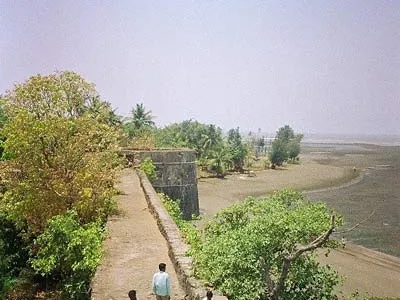
Arnala
In 1516, a local chieftain in Gujarat, Sultan Mahmud Begda originally constructed the fort on the island, strategically located at the mouth of the Vaitarna river…
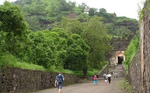
Daulatabad
The fortress of Daulatabad is surrounded by 5 km of sturdy walls. The central bastion tops a 200m high hill, originally known as Devagiri, the Hill of the Gods. It…
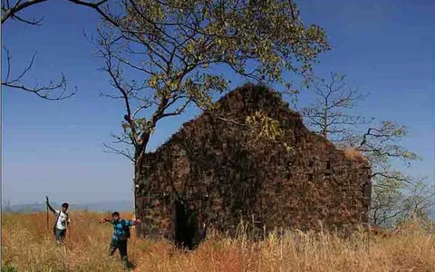
Karnala
Karnala is 120 km from Pune and 13 km from Panvel. Between Pune and Panvel lies the Fort Karnala.