Chembra Peak Trekking And Camping
This 344 km² from trivendrum city and is about 16 km east of Sultan Battery, kerala.Mysore - Nanjangod - Gundlupet - Muthanga WLS - Sulthan bathery (140 kms) and ooty - Meppadi - Kalpetta (100 kms).
Summary
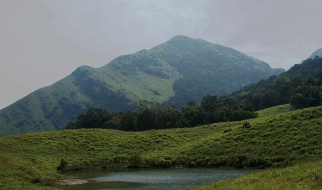
Chembra Peak is situated in near the town of Meppady and is 14 km west of Kalpetta, Wayand district.he peak stands 2100 meters above the sea level and is part of the Meppadi Forest Range. It will take one and half hour of strenuous trek to reach the central point of the peak from the watch tower. At the zenith there is a heart-shaped perennial lake where drinking water is available from the nearby natural springs even at the height of summer. It is part of the Wayanad hill ranges in Western Ghats, adjoining the Nilgiri Hills in Tamilnadu and Vellarimala in Kozhikode district in Kerala. Chembra peak is accessible by foot from Meppady. District Tourism Promotion Council provides guides and trekking equipments on hire charges to the tourists. For those adventure seekers, temporary camps are set up on the top of the peak. Guides, camping apparatus etc are provided by District Tourism Promotion Council on rent to tourists who are interested in camping and trekking. Discover a redefine version of pleasure and adventure on oyur Chembra Peak tour in Kerala.The entire region is quite picturesque with tea plantations and a variety of flora and fauna and some wild life in the jungles.Tourists can also stay one or two days at the top of the peak in temporary camps. A destination for trekkers as well as nature lovers, some tourists stay one or two days at the top of the peak in temporary camps. The temperature really falls down at the top of the peak. A heart shaped lake en route to the top of the peak is a major tourist attraction. The lake is believed to have never dried up.
A large part of the mountain is forest and a lot of animals including elephants, deers, leopards etc. Rest region has large grasslands, tea estates and human habitation. t is a delightful spot for the trekkers as well as for the nature lovers.The entire surrounding is quite with tea plantation, flora and fauna, beautiful birds and some wild life.When you will reach on the top of the Chembra Peak Kerala it is guaranteed that you will forget your pain and stress. You will be captivated by nature’s bounteous beauty. The kaleidoscopic view of Wayanad from the top of the peak is breathtaking.
Things To Look for
Soochipara Falls:
The Soochippara waterfalls are situated near Meppadi and are real treasures of nature. The waterfall ranged from 100 to 300 feet in height and is a luxury to the eyes. This is a prominent place for leisurely destination. And this place is a blessed place as its divinity is obvious in the beauty of the nature.This falls is around 22 km from Kalpetta.
Edakkal Caves:
The Edakkal Caves in Wayanad are magnificent formations of nature. The word ‘Edakkal’ itself means ‘a stone in between’. The structure of these caves is truly extraordinary as a big boulder balances itself on two relatively smaller boulders, thus forming the truly fascinating Edakkal Caves of Kerala. These caves are a very popular tourist attraction of Wayanad. The cave has two levels inside that can be entered through an entrance that is merely 5 feet in height.
The lower chamber is around 18 feet long and 10 feet high. A small passage from there leads to the upper chamber that is around 95 feet long and 18 feet high. This truly magnificent structure is a storehouse of pre-historic art forms. This attracts historians and archaeologists from all over the world. The Edakkal Caves have been the cradle of human civilization at different stages in history.
Meenmutty falls:
It is a three-tiered waterfall with a height of 300 metres. Meenmutty Falls, the largest and most spectacular waterfall in the Wayanad District, is a 2 km hike though the jungle from the main Ooty Road. It is Kerala’s second largest waterfall and the one most unspoiled in its natural setting. Each of its three tiers requires a separate hike through a moist, deciduous forest.
Kanthapara Falls:
About 25 km north-east of Kalpetta is Padinjarathara Dam. This dam is 2nd largest in Asia and is attractive with serene environment engulfing it. Padinjarathara is surrounded by mist capped mountains and wildlife sanctuary. Picturesque ambience, beautiful location and divine.
Sentinel rocks falls:
Locally known as Soochipara, this is a very popular leisure destination. While younger visitors love to romp in the pool formed at the foot of the fall, the more restrained can have equally good fun just taking in the scenery.
Tholpetty Wildlife Sanctuary :
Tholpetty Wildlife Sanctuary (20 km east of Mananthavady): This sanctuary has a wide variety of animals. Visiting time: 0600 - 0800 hrs and 1500 -1730 hrs.
Location info
-
Distances: 14 km west of Kalpetta, Wayanad District, kerala
-
Camping Sites:Camping in the night at the top of the Chembra peak
-
Trek Length: 2100 meters above the sea level
Helpline & emergency contacts
Vana Samrakshana Samiti Office
ph:+919495757681.
Mobile network coverage
Airtel, Jio, BSNL, and Vi all provide coverage across Kerala. 4G is reliable in Kochi, Thiruvananthapuram, Kozhikode, and along the coastal belt. Coverage may be weaker in remote sections of the Western Ghats, deep forest reserves, and certain backwater stretches. Most hotels, houseboats, and cafes in tourist areas offer free Wi-Fi.
Food & restaurants nearby
Food options are available in the nearest town. Kerala cuisine — fish curry, appam with stew, puttu, and Kerala sadhya — is widely available and famously delicious.
Hotels & accommodation nearby
Accommodation is available in the nearest town or city. Options range from homestays to luxury resorts. Kerala’s homestay network is excellent and offers authentic local experiences.
Climate & weather
Kerala has a tropical monsoon climate with warm, humid conditions year-round. The best time to visit is November to February, when temperatures are a pleasant 22°C–30°C with low humidity and clear skies. March–May is hot and humid (up to 36°C). The southwest monsoon (June–September) brings heavy rainfall — the landscape transforms into lush green and this is the best time for Ayurvedic treatments. The northeast monsoon (October–November) brings shorter showers. Hill stations (Munnar, Wayanad) remain cooler year-round.
Nearest petrol pump
Petrol pumps are available in the nearest town or on the approach road — check locally for the closest option.
Accessibility
Accessibility information is not currently available for this site. Contact the venue directly or check with your accommodation for the latest accessibility details.
Rules & restrictions
Standard visitor rules apply. Check locally for any specific restrictions at this site.
Best photography spots
The best photography spots are typically during the golden hours (early morning and late afternoon). Scout the location first to identify the best angles, and consider the direction of light at different times of day.
Best time to visit Chembra Peak Trekking And Camping
The best time for trekking at Chembra Peak Trekking A Camping is from November to February when the weather is cool and dry with clear skies. Post-monsoon (September–November) offers lush green landscapes. Monsoon trekking is not recommended due to slippery trails and leeches. Summer treks are possible in early mornings but afternoons can be hot.
How to reach Chembra Peak Trekking And Camping
Nearest Airport: Calicut International Airport (CCJ) (approximately 40 km). Nearest Railway Station: Kozhikode Railway Station. The destination is well-connected by Kerala State Road Transport Corporation (KSRTC) buses and private taxis from major towns.
Timings & opening hours
Trekking routes are accessible from 6:00 AM to 5:00 PM. All trekkers must start their trek before 10:00 AM and must complete it before sunset. Night trekking is not permitted without special permission.
Entry fee & tickets
Trekking permit fees: INR 100–500 per person for day treks. Guide charges: INR 500–1,500 per day. Forest entry fee: INR 25–50 per person. Some restricted areas (like Agasthyakoodam) require special permits from the Forest Department months in advance.
Duration needed
Half day (3–5 hours) for short treks. Full day (6–8 hours) for moderate treks. Multi-day treks require camping arrangements and advance booking.
Safety tips
Always hire a local guide for trekking routes — especially in forested and hilly areas. Carry sufficient water (at least 2 litres per person) and snacks. Start your trek early in the morning (before 7:00 AM) and aim to finish before 3:00 PM. Wear sturdy trekking shoes with good grip. Inform someone about your trekking route and expected return time. Check weather conditions before heading out.
Things to carry
Trekking shoes with good grip and ankle support (essential), rucksack/backpack (30–40 litre capacity), 2–3 litres of drinking water, high-energy snacks (nuts, dry fruits, energy bars), a first-aid kit (bandages, antiseptic, pain relievers, blister plasters), insect repellent, sunscreen, hat, raincoat/poncho, whistle (emergency), torch/headlamp with extra batteries, a map or GPS-enabled phone, and a small towel. Hire a local guide for unfamiliar routes.
Nearby visiting places
Edakkal Caves, Banasura Sagar Dam, Pookkode Lake, Wayanad Wildlife Sanctuary, Chembra Peak, Kuruva Island, Thirunelli Temple, Soochipara Waterfall
Nearest airport, railway & bus
Nearest Airport: Calicut International Airport (CCJ) (approximately 40 km). Nearest Railway Station: Kozhikode Railway Station. The destination is well-connected by Kerala State Road Transport Corporation (KSRTC) buses and private taxis from major towns.
History of Chembra Peak Trekking And Camping
The trekking trails at Chembra Peak Trekking A Camping traverse the beautiful terrain of the Western Ghats, a mountain range that runs parallel to Kerala’s coast and is recognised as a UNESCO World Heritage Site. The Ghats are one of the most biologically diverse regions on Earth, with trekking routes passing through shola forests, grasslands, tea plantations, and spice gardens. These trails have been used by local communities for centuries for travel and trade between the coast and the interior.
Things to do at Chembra Peak Trekking And Camping
Trek through scenic trails passing through shola forests and grasslands, spot wildlife and birds along the trail, photograph the panoramic mountain views, enjoy a packed lunch at a scenic viewpoint, identify unique flora including medicinal plants and orchids, camp overnight (on multi-day treks), learn about the ecosystem from your guide, and challenge yourself physically while connecting with nature.
Things to visit & highlights
The scenic trekking trails through forests, grasslands, and plantations, panoramic viewpoints offering stunning valley views, diverse flora including endemic species and orchids, wildlife sightings along the trail, and the sense of adventure and connection with nature.
Frequently asked questions
Do I need a guide for trekking? — Yes, a local guide is strongly recommended and mandatory in some areas. Guides know the terrain, can point out wildlife, and ensure your safety. What fitness level is required? — Most treks in Kerala range from easy to moderate. Some treks (like Agasthyakoodam and Chembra Peak) require good physical fitness and stamina. Check difficulty levels before booking. What should I carry? — Sturdy trekking shoes, 2–3 litres of water, snacks, sunscreen, hat, raincoat, insect repellent, first-aid kit, and a camera. Do I need a permit? — Some treks require permits from the Kerala Forest Department. Agasthyakoodam treks require advance permits (limited to 100 per day) during the season.
Quick facts
- Type: Tourist Attraction
- State: Kerala
- Category: Trekking Camping
Visitor information
Please check locally for current visitor information.
Map & location view
This section is being updated and will be available shortly.
Photo gallery of Chembra Peak Trekking And Camping
Video gallery
Related destinations
Agasthyakoodam Trekking And Camping
NH7 to Tirumangalam via Salem, Dindigul and Madurai. NH208 to Thenmala via Tenkasi and Shencottai; state road to Ponmudi.
Anamudi Trekking And Camping
Marayoor is approximately 40 kilometers away from Munnar region.There many bus tranport system from government of kerala.
Dhoni Trekking And Camping
The important road is the Palakkad - Ponnani road which connects NH 47 and NH 17. It is on NH47 that links Salem to Kanyakumari via Palakkad.