Wainganga River
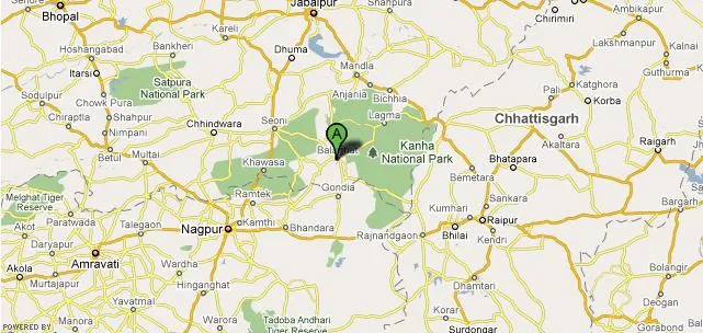
The Wainganga is a river of India, which originates about 12 Km from Mundara village of Seoni district in the southern slopes of the Satpura Range of Madhya Pradesh, and flows south through Madhya Pradesh and Maharashtra in a very meandering course of roughly 360 miles. After joining the Wardha, the united stream was called the Pranahita, finally empties into the River Godavari. The river has urbanized extensive flood plains with sweeping graceful meanders and low alluvial flats and meander…
About Wainganga River
The Wainganga is a river of India, which originates about 12 Km from Mundara village of Seoni district in the southern slopes of the Satpura Range of Madhya Pradesh, and flows south through Madhya Pradesh and Maharashtra in a very meandering course of roughly 360 miles. After joining the Wardha, the united stream was called the Pranahita, finally empties into the River Godavari. The river has urbanized extensive flood plains with sweeping graceful meanders and low alluvial flats and meander terraces. The river has high banks 10 to 15 m on either side. The Wainganga river receives numerous tributaries on either bank and drains the western, central and eastern regions of the Chandrapur, Gadchiroli and Nagpur districts. The principal tributaries of the Wainganga are the Garhavi, Kathani, Khobragadi and Potphondi on the western bank and Andhari on the eastern bank.
The Kathani River originates in the Dhanora Pendhri Hills and merges Wainganga near Gadchiroli city. Chandan River is another important tributary of Wainganga of the Balaghat district. Rudyard Kipling used the Wainganga or Wangunga in older editions as a major attraction in the Mowgli stories of The Jungle Book and The Second Jungle Book (1894 - 1895). This river is the primary source of water for all the people of the jungle, the location of the Peace Rock, the place where Shere Khan vows to place Mowgli`s bones once he has killed him, and the final battlefield in “Red Dog”. However, the region around the Wainganga is not really a rainforest.
Interesting things to Visit
Beemgarh Dam is the famous mud dam built across the Wainganga at the village of Beemgarh. It is a scenic spot surrounded by forests and is about 90km from the source of the river.
Dalsagar Sarovar is a beautiful 50 sq km lake on the way to Jabalpur and is covered by waterlilies.
Mata Rajrajeshwari temple in Seoni town attracts many pilgrims, as does the sacred and ancient Shri Ram Mandir, 1km away from the town.
Digambar Jain temples is a group of 18 Jain temples built in the city in 1883.
Nearest Visiting places
Ashta Kali Mandir, 43 km away from Seoni was built by Himadri Pundit, a legendary figure of the area. He is credited to have built this stone temple overnight and its architecture laid the foundations for the local Himandpanthi style of temple building.
Pench Tiger Sanctuary is a famous reserve forest spreading over M.P. and Maharashtra. Apart from tigers it also has many other animals and birds.
Can also visit,Bandhavgarh National Park and.Kanha National Park.
Help Line/Phone Number
Nearest Hospital:
1.Jathar Hosptial,Seoni.
2.Indira Gandhi City Hospital, Seoni.
Copyright 2016 HolidayLandmark All rights reserved
Location info
-
Address: Seoni,Maharashtra,India
-
District: Seoni District
-
Nearest City: Nagpur
-
Best time to visit: Nov to Feb
Climate & weather
Pleasant and equable climate throughout the year.
Things to do at Wainganga River
Enjoy the scenic beauty of the wainganga river and explore the nearby places,temples sanctuary’s and so on.
How to reach Wainganga River
-
**Nearest Railway Station:**Seoni Railway Station.
-
**Nearest Airport:**Sonegaon Airport, Nagpur.
**Road Transport:**Seoni is connected to almost all the places in Madhya Pradesh and Maharashtra by good road and rail networks.Hence makes it easily reachable.
Hotels & accommodation nearby
Lots of Good hotels and Lodges are available in seoni district and nearby cities.
Best time to visit Wainganga River
July to March: post-monsoon when water levels are good. During summer, some rivers may run dry.
Timings & opening hours
Accessible 24 hours. Best visited during daylight hours.
Entry fee & tickets
Free entry. Boat rides or guided tours are charged separately.
Duration needed
1–2 hours at a specific ghat or access point. Half-day for boat rides and riverside activities.
Safety tips
Do not swim in unknown or deep sections of the river. Be cautious of strong currents, especially during and after monsoon. Avoid bathing at isolated ghats after dark.
Things to carry
Water bottle, camera, comfortable footwear, and a hat. For boat rides, carry a life jacket (usually provided).
Nearest airport, railway & bus
Nearest airport: the nearest city airport. Nearest railway station: the nearest station on the Central Railway. Accessible by road from nearby towns and cities.
Mobile network coverage
Airtel, Jio, and Vi all provide excellent coverage across Maharashtra’s cities (Mumbai, Pune, Nagpur) and major tourist areas. 4G is reliable along highways and in most towns. Coverage may be weaker in deep forest areas of Tadoba, Melghat, and certain ghat sections. Free Wi-Fi is widely available in hotels and cafes.
Food & restaurants nearby
Food options are available in the nearest town. Maharashtrian cuisine — missal pav, vada pav, puran poli, and local thalis — is widely available.
History of Wainganga River
Rivers in Maharashtra have sustained human settlements, agriculture, and culture for millennia. They are integral to the state’s geography and economy, providing water for irrigation, industry, and domestic use.
Nearest petrol pump
Petrol pumps are available in the nearest town or on the approach road to Wainganga River. It is advisable to fill fuel before heading to remote areas, especially hill forts and wildlife sanctuaries.
Frequently asked questions
What is the best time to visit? Post-monsoon (October–February) when water levels are good offers the best experience. During summer, some rivers may have reduced flow.
Are boat rides available? Boat rides are available at several major river locations. Check locally for availability, types of boats, and safety equipment.
Which are the major temples along this river? Several important temples and ghats are located along the major rivers of Maharashtra, especially the Godavari, Krishna, and Panchganga.
Quick facts
- Location: Maharashtra
- Best time to visit: November to March for pleasant weather
- Ideal duration: 1-2 hours for riverside walks and photography
- Entry: Free access to riverside areas
- Activities: Photography, riverside picnics, and nature walks
Map & location view
- Destination: Wainganga River
- State: Maharashtra, India
- Region: riverine landscape of Maharashtra
- How to reach: Accessible by road from nearby towns and cities. Local transport options include buses and taxis.
- Google Maps: Search for “Wainganga River, Maharashtra” on Google Maps for precise directions and navigation.
Photo gallery of Wainganga River
Photos coming soon. In the meantime, you can find images of Wainganga River on popular travel photography sites and social media.
Photo gallery of Wainganga River
Video gallery
Related destinations
Bhima River
The Bhima River rises from the Bhimashankar hills, located in the Sahyadri range of the Western Ghats, near Karjat in Maharashtra. Covering a length of…
Bindusara River
Bindusara (also called Bendsura) is a small river situated in the district of Beed in Maharashtra state of India. It is a tributory river of Sindphana and a…
Dahisar River
Dahisar River is a river in the northern suburbs of Mumbai near the suburb of Dahisar. It originates in the Tulsi Lake in the Sanjay Gandhi National Park in the…