Ulhas River
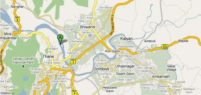
The Ulhas River is a river flowing in the western part of India. It rises at the foothills of the Sahyadris near Karjat in the Western Ghats Range and starts flowing in the west direction. It enters the Thane and Raigad districts of Maharastra between Kulgaon-Badlapur towards the north of Ulhasnagar and then moves towards Kalyan. Then the river turns in the west direction towards Thane and a channel connects it to the Thane Creek.
About Ulhas River
During its course the Ulhas river meets the Barvi River, which is actually the discharge water of Barvi Dam. This meeting point is a tourist spot and a fishing spot for villagers. It is at Thane the river separates into two. One branch flows in the west direction and the other branch in the south direction. It is around the Salsette Island where lies the city of Mumbai. The two branches are estuarine in nature and they lie on seismic fault line.
The river then turns in the northwest direction towards Ghodebunder, where it opens into an estuary known as Vasai Creek.The Thane Creek flows in the south direction and empties into the Bombay Harbour. The estuary of Ulhas houses several historical ports of Kalyan, Kopri and Shurparaka. The important tributaries of the Ulhas River are Bharvi, Bhatsa and Kalu rivers.
Interesting things to do
River Rafting,Karjat:
Karjat on the banks of the Ulhas river is a perfect place for many water sports activities. River Ulhas tempts the tourists to have a great experience of river rafting in the most exciting cool and calm waters perfectly blended with nature, Karjat’s river rafting is really an adventurous experience, with many of the visitors offer themselves for the passion.
Trekking,karjat:
Karjat is a renowned area for trekking due to its undulated hilly terrains and slopes. Karjat offers medium to very demanding adventurous trekking trails. The adventurous trekkers can get the required level of challenge from the trekking tracks in Karjat. These trails are mostly unexplored and unspoiled. The cool and calm ambience makes it a perfect place for nature trekking.
Interesting things to Visit
Kondana Caves:
Kondana Caves situated in Karjat offers the ancient lifestyle of Buddhist followers. Ancient rock-cut caves, Kondana Caves are very famous Buddhist caves. These caves enclose sculptures, vihara, cahitya and stupa. Sculptures and stupas are specimens of the ancient period Buddhist architecture. There was a natural disaster in the form of an earth quake in early 1900 by which many stupas, front entrance and floor of the caves were damaged.
Peth Fort:
Peth Fort, also known as Kotligad, is a major attraction of the small village Peth nearby to Karjat in its north east region. Peth is a conically shaped hill and it offers a panoramic view of the foothills. The fort is at the pinnacle of the mount and it is placed perfectly on the back drop of Matheran ranges and Western Ghats. One can view the Konkan country side from the fort and the beauty of this view is majestic.
Nearest Visiting places
Ulhas Valley:
This valley glitters with large flowing streams of Ulhas river. It offers breathtaking sights during the monsoons, when the water falls gush through the thick greenery of the valley. There are a number of tunnels in the Ulhas valley, which helps the trains to pass through the valley.
Bhor Ghat:
This ghat has a historical significance. It was the ancient trade route connecting the ports at Choul, Revdanda, Panvel, etc. on the Konkan coast and the hinterland on the Deccan plateau.
Kondheshwar temple:
This temple is located in Sandshi. The beautiful architecture of the temple makes it a favourite tourist spot.
Bahiri Cave:
This cave is famous for trekking. Its characteristic long and strenuous streches makes it a challenging trekking adventure. However it is advised that an expert should accompany a trekking trip in this cave.
This cave stands facing the Ulhas Valley at an altitude of 600m. this cave is religious for many Hindu devotees. On the day of Chaitra Purnima a fair is held in the area.
Nakhind:
Nakhind is a hill, that stands at an altitude of 704m high.This hill is marked by the flawless view of the ghats.
Chanderi:
This magnificient massif stands at a height of 790m . Chanderi is joined to a group of “four pinnacles” called Mhasmal. A cave at the base of Chanderi is famous for one-day trekking.
Bhimashankar Area:
Located in the Sajyadri ranges, Bhimashankar is a huge massif, with a thick reserve forest. It stands at an altitude of 1005m. At the top of this massif, there is a huge plateau where the Bhimashankar town and the Bhimashankar temple are situated. Bhimashankar is a popular pilgrimage spot, since the Bhimshankar templem dedicayed to Lord Shiva is one of the 12 Jyotirlingas of Shiva. The highest point of the massif is Nagphani, because it looks like the hood of a cobra from a distance. The Bhima river originates from here and flows down towards the Deccan
Peth:
An interesting conical hill, Peth offers a spectacular view of a thumb like pinnacle. The pinnacle is a fort, and is known as Kotligad. Peth oofers breathtaking views of the Konkan Country side, Western Ghats and Matheran Ranges.
Help Line/Phone Number
Nearest Hospital:
Gokul Hospital,Karjat
Phadke Hospital,Karjat
The Kundalika is a small river flowing from the Hills of Sahyadri to the Arabian Sea. This river originates at a small town called Bhira in the Indian State of Maharashtra, 150 km south east of Bombay (Mumbai). The important towns located on the banks of Kundalika are Kolad, Roha and Salav.River Kundalika is fed by the excess water from Tata Power’s Mulshi Dam Project on to a series of hydroelectric projects and dams, including Ravalje followed by Bhira and then Dholvan, where the water is released in the morning typically at 6 am…..more
River Vashishti is one of the larger rivers in the Konkan coast of Maharashtra, India. The town of Chiplun lies on its banks. The river begins in the Western Ghats and snakes its way westwards towards the Arabian Sea. Kolkiwadi Dam, near Alore has a vast reservoir which feeds a tributary of the river. During the 2005 Maharashtra floods, the river swelled its banks, causing many of the city’s residents to evacuate it……more
Alibag or Alibaug is a coastal town and a municipal council in Raigad District in the Konkan region of Maharashtra, India. It is headquarters of the Raigad district.Alibag (also called Alibagh or Alibaugh) is an idyllic, peaceful town on the western coast of India (which is known as the Konkan region). It lies on almost the same latitude as the southern tip of Mumbai and is very close to this tip across the narrow strip of the Arabian Sea, conquerable by a ferry…..more
Shriwardhan-Harihareshwar Beach is the two unexplored beaches on the Konkan coastline. If you are an adventurous person and die on seafood delicacies, Shriwardhan Beach is the place where you should be.The water is inviting and can be explored on a boat, sailing deep into the sea, cutting through the gentle winds. A small adventurous boat ride will take you to a place where Peshwas originally resided. Shriwardhan-Harihareshwar Beach is about 200km from Mumbai……more
Padmadurg is a fort in Maharashtra, India. It was built by shivaji to northwest of Janjira. Although it is not as big as Janjira but still a sea fort that can be visited and enjoyed.Spread over a vast area of about 9 acres, Padmadurg Fort is regarded as one among the major sea forts in India. A monument of great historical importance, it is situated in Raigad District of Maharashtra. This famous fort is constructed by the great Marathas in order to conquer the Janjira Fort which lies near by……more
Karnala is 120 km from Pune and 13 km from Panvel. Between Pune and Panvel lies the Fort Karnala.Just 10 km off the busy Mumbai-Pune highway a sign welcomes visitors to the Karnala Bird Sanctuary. As the road winds up a little ghat on Mumbai-Goa highway, travel-weary visitors feel a sudden freshness in the air as they enter this pocket-sized Eden…..more
Copyright 2016 HolidayLandmark All rights reserved
Location info
-
**Address:**Karjat,Mumbai,Maharashtra,India
-
District: Raigad District.
-
Nearest City: Karjat
-
Best time to visit: Nov to Feb and April to June.
Climate & weather
Climate is subtropical,with mild winters and warm summers.
How to reach Ulhas River
-
**Nearest Railway Station:**Karjat.
-
Nearest Airport: Mumbai International airport.
-
Road Transport: Karjat is 100km from Mumbai. State buses ply from Mumbai to Karjat.
Best time to visit Ulhas River
July to March: post-monsoon when water levels are good. During summer, some rivers may run dry.
Timings & opening hours
Accessible 24 hours. Best visited during daylight hours.
Entry fee & tickets
Free entry. Boat rides or guided tours are charged separately.
Duration needed
1–2 hours at a specific ghat or access point. Half-day for boat rides and riverside activities.
Safety tips
Do not swim in unknown or deep sections of the river. Be cautious of strong currents, especially during and after monsoon. Avoid bathing at isolated ghats after dark.
Things to carry
Water bottle, camera, comfortable footwear, and a hat. For boat rides, carry a life jacket (usually provided).
Nearest airport, railway & bus
Nearest airport: the nearest city airport. Nearest railway station: the nearest station on the Central Railway. Accessible by road from nearby towns and cities.
Mobile network coverage
Airtel, Jio, and Vi all provide excellent coverage across Maharashtra’s cities (Mumbai, Pune, Nagpur) and major tourist areas. 4G is reliable along highways and in most towns. Coverage may be weaker in deep forest areas of Tadoba, Melghat, and certain ghat sections. Free Wi-Fi is widely available in hotels and cafes.
Food & restaurants nearby
Food options are available in the nearest town. Maharashtrian cuisine — missal pav, vada pav, puran poli, and local thalis — is widely available.
Hotels & accommodation nearby
Accommodation is available in the nearest town or city. MTDC resorts, budget hotels, and mid-range options are widely available.
History of Ulhas River
Rivers in Maharashtra have sustained human settlements, agriculture, and culture for millennia. They are integral to the state’s geography and economy, providing water for irrigation, industry, and domestic use.
Nearest petrol pump
Petrol pumps are available in the nearest town or on the approach road to Ulhas River. It is advisable to fill fuel before heading to remote areas, especially hill forts and wildlife sanctuaries.
Frequently asked questions
What is the best time to visit? Post-monsoon (October–February) when water levels are good offers the best experience. During summer, some rivers may have reduced flow.
Are boat rides available? Boat rides are available at several major river locations. Check locally for availability, types of boats, and safety equipment.
Which are the major temples along this river? Several important temples and ghats are located along the major rivers of Maharashtra, especially the Godavari, Krishna, and Panchganga.
Quick facts
- Location: Maharashtra
- Best time to visit: November to March for pleasant weather
- Ideal duration: 1-2 hours for riverside walks and photography
- Entry: Free access to riverside areas
- Activities: Photography, riverside picnics, and nature walks
Map & location view
- Destination: Ulhas River
- State: Maharashtra, India
- Region: riverine landscape of Maharashtra
- How to reach: Accessible by road from nearby towns and cities. Local transport options include buses and taxis.
- Google Maps: Search for “Ulhas River, Maharashtra” on Google Maps for precise directions and navigation.
Photo gallery of Ulhas River
Photos coming soon. In the meantime, you can find images of Ulhas River on popular travel photography sites and social media.
Photo gallery of Ulhas River
Video gallery
Related destinations
Bhima River
The Bhima River rises from the Bhimashankar hills, located in the Sahyadri range of the Western Ghats, near Karjat in Maharashtra. Covering a length of…
Bindusara River
Bindusara (also called Bendsura) is a small river situated in the district of Beed in Maharashtra state of India. It is a tributory river of Sindphana and a…
Dahisar River
Dahisar River is a river in the northern suburbs of Mumbai near the suburb of Dahisar. It originates in the Tulsi Lake in the Sanjay Gandhi National Park in the…