Alirajpur District
Alirajpur (also known as Ali Rajpur) is a city and a municipality in Alirajpur district in the state of Madhya Pradesh, India.
About Alirajpur District
Alirajpur (also known as Ali Rajpur) is a city and a municipality in Alirajpur district in the state of Madhya Pradesh, India.
Alirajpur was formerly a princely state of India, under the Bhopawar agency in Central India. It lies in the Malwa region of Madhya Pradesh, near the border with Gujarat and Maharashtra. It has an area of 836 m². The country is hilly, and many of the inhabitants are aboriginal Bhils. It has from time to time been under British administration. The chiefs of the tribes, whose title was Rana, were generally Rathore Rajputs. The Victoria bridge at Alirajpur was built to commemorate the Diamond Jubilee of 1897.
Area-wise,Formerly Alirajpur taluka is bigger than the Jhabua taluka of Jhabua district,Now Alirajpur Is District. The Rajwara fort is situated in the centre of the town attached with a beautiful playground known as Fateh Club. Alirajpur is also the hub for Bhils for different kinds of trade and business.
Alirajpur district is one of the 50 districts of Madhya Pradesh state in India. The district was carved out from the erstwhile Jhabua district on May 17, 2008 by incorporating Alirajpur, Jobat and Bhavra tehsils of it. Alirajpur town is the administrative headquarters of this district. The district occupies an area of 2165.24 km² and has a population of 2,488,003 (2001 Census).
History of Alirajpur
It was formerly a princely state of India, administratively under the Bhopawar Agency subdivision of the Central India Agency. The state covered an area of 2165 square kilometres, with a population of 50,185 in 1901. Its Hindu rulers were styled Raja, and were entitled to an 11-gun salute. The flag consisting of 12 red and white horizontal stripes.
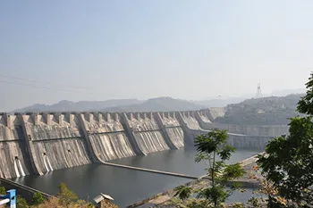
The villages of Alirajpur are the first in Madhya Pradesh to be affected by the Sardar Sarovar Project (SSP). They are all Adivasi communities with a mixed economy based on agriculture (on titled land as well as forest encroachments), forest produce, herding, and fishing. The cash component of the economy is relatively minor and these communities have strong cultural ties with the forest and river. As tribal communities they have a social system marked by egalitarianism (there are no landless people in these villages) and a strong sense of community. They have their own religious beliefs, cultural practices, and an independent language. Being Adivasis, one of the most vulnerable sections of our society, they have been granted special protection through the Schedule V of the Constitution, the Panchayats (Extension to the Scheduled Areas) Act 1996, various protective national and State legislation, and several International Treaties including the ILO 107 that has been ratified by the Indian government.
Some of the villages of Alirajpur were partially submerged by the SSP as far back as 1994. Although there was a four-year respite due to stoppage on construction following the Supreme Court’s stay, fields in many villages have been affected every year due to pondage. No compensation for crop losses has ever been provided.
The district is named after its headquarters, Alirajpur, which was the capital of the former princely state of Ali Rajpur. The name of this town is derived by conjoining Ali (the fortress town and the former capital of the princely state founded by Anand Deo in 1437) and Rajpur (the latter capital).
Bhopal,17 May:Chief Minister Shri Shivraj Singh Chouhan dedicated Alirajpur, 49th district of the state to the people in the presence of massive gathering. With this Alirajpur, which was hitherto a part of Jhabua district, has come into existence as a new district.
The Chief Minister introduced the first collector of the new district Shri Chandrashekhar Borkar to the people from the stage. He also announced to give status of Tahasil to Kathiwada and Sondwa on this occasion. The Chief Minister announced to give Rs one crore for administrative arrangments at Alirajpur district headquarter. Those present on the occasion included Minister of State for Tribal Welfare Smt. Ranjana Baghel, Alirajpur MLA Shri Nagar Singh Chouhan, Jobat MLA Shri Madhosingh Dabar, Jhabua MLA Shri Pawaisingh Pargi and Thandla MLA Shri Kalsingh Bhamar.
Thus apart from meeting the longstanding demand of people, the Chief Minster has also fulfilled the promise he had made at Umarali village on November 1, 2007. It may be mentioned that Chief Minister Shri Chouhan had announced that that he would make Alirajpur a district while launching Mukhyamantri Mazdoor Suraksha Yojana at Umrali village of Jhabua district.
The principality was founded in the 1437 by the Rajput Rathore dynasty. The last ruler of Ali Rajpur was Surendra Singh, who subsequently served as the Ambassador of India to Spain in the 1980s. After Indian independence in 1947, Ali Rajpur acceded to the Union of India, and the principality was incorporated into the new state of Madhya Bharat, which subsequently became Madhya Pradesh state on November 1, 1956.
Culture
Alirajpur is a district of Madhya Pradesh. It has a total area of 2165.24 square kilometers. As of the census taken in 2001, the district has a total population of 2,488,003 people spread in around 551 villages. The district’s boundaries include the neighboring states of Maharashtra and Gujarat; it is situated in the Malwa region of Madhya Pradesh. Many of the inhabitants are aboriginal. At least 55% of the total population of the district is Bhilala, 21% is Patlya, 15% is Bhil with the remaining 9% is made up by diverse groups. The town of Alirajpur serves as the district’s administrative headquarters.
Presently, there are two Madhya Pradesh Vidhan Sabha constituencies in this district: Alirajpur and Jobat.Both of these are part of Ratlam Lok Sabha constituency.
Alirajpur’s topography is predominantly hilly. Its economy depends primarily on agricultural endeavours, especially farming, especially mangoes. The agricultural trading yard in Alirajpur is the biggest in all the state when it comes to mango trading. Also, the Noor Jahan, a very rare variety of mango of which only four trees are currently surviving, can only be found in the district, specifically in the town of Katthiwara.
The district is also famous for wood carvings which display exquisite and beautiful craftsmanship. Owing to the fact that there is a significant population of the Bhils tribe in the region, the district has also become the hub for Bhils for different kinds of trading and businesses.
While tourism isn’t a major industry, there are several Jain temples located in Alirajpur that are worth seeing. The Laxmaniji Teerth, for example, houses the idol of Padma Prabhu Swami as its main deity. Another temple worth seeing is the Shri Laksamani Teerth located some 8 kilometers from the main headquarter town. This 2000-year old temple sports a large main hall, with 140 colorful and artistic stone archives hidden away in the inner halls. The temple’s main deity is Shri Padmaprabh Bhagvan, in a white stone idol in the padmasana posture.
Alirajpur (also known as Ali Rajpur) is a city and a municipality in Alirajpur district in the state of Madhya Pradesh, India. Alirajpur was formerly a princely state of India, under the Bhopawar agency in Central India. It lies in the Malwa region of Madhya Pradesh, near the border with Gujarat and Maharashtra. It has an area of 836 m². The country is hilly, and many of the inhabitants are aboriginal Bhils. It has from time to time been under British administration. The chiefs of the tribes, whose title was Rana, were generally Rathore Rajputs. The Victoria bridge at Alirajpur was built to commemorate the Diamond Jubilee of 1897. Area-wise,Formerly Alirajpur taluka is bigger than the Jhabua taluka of Jhabua district,Now Alirajpur Is District. The Rajwara fort is situated in the centre of the town attached with a beautiful playground known as Fateh Club. Alirajpur is also the hub for Bhils for different kinds of trade and business. It was formerly a princely state of India.In Alirajpur division which is in the south of Jhabua the area is almost entire hilly and intersected by narrow valleys and low Vindhayan ranges covered with jungles.
Tourist Attraction of Alirajpur
This place is famous for its craftsmanship on woodcarvings. There is a trekking route from Jobat to this destination. Laxmaniji Tirth, a jain pilgrimage center is 8 km away.
Malwai
Malwai is located 5 km. South of Alirajpur on the unmetalled road leading to Alirajpur and Walpur, before it bifurcates for Umrali. It settles on the northern foothills of the Vindhyachal Range in Alirajpur Tahsil. There is am ancient but small shiva temple in ruinous condition. The platform is rectangular but several conical columns rising from the base reach up to the kalash , which has fallen. The front portion of the cone has also fallen. Many beautiful carvings and images in the row of Penals are Visible whicn can be assigned to 12th-13th century.
Amkhut
Amkhut village is 24 km. North-west of Alirajpur on Alirajpur-Kathiwara Fairweather Road. The place is located among the forests of the Vindhachal range. It enjoys a natural beauty and cool climate . The Canadian Christian Mission established its centre here ami amidst the tribal villages. The village has a gram panchayat, a police out post, a primary school and rest house maintained by the Forest Department. The village has been electrified.
The Rajwara fort is situated in the centre of the town attached with a beautiful playground known as Fateh Club. Alirajpur is also the hub for Bhils for different kinds of trade and business.
Copyright 2016 HolidayLandmark All rights reserved
Location info
Situated at an altitude of about 300 m above sea level, Alirajpur is a town in Jhabua District, Madhya Pradesh. It lies to the south-west of Jobat.
Climate & weather
Climate is generally moderate and seasons are well defined. The summers are hot, winters are short and the monsoon season is generally pleasant. The average rainfall in the district is about 800mm. Most of the rainfall occurs in monsoon season while there is also a little of rainfall in winter season
How to reach Alirajpur District
**Nearest Railway Station:**The nearest railway station in Alirajpur is the Dahod Railway station in Gujarat.
However, on February 8, 2008, the foundation for the Badodara-Dhar broad-gauge rail line was laid, promising complete rail connectivity of the district to the others.
-
**Nearest Airport:**The nearest airport is found in Indore, the Devi Ahilya Bai Holeker airport.
-
**Road Transport:**Buses ply frequently from Bhabhara to Alirajpur.
Best time to visit Alirajpur District
October to March (winter) for pleasant weather
Timings & opening hours
District office: 10:00 AM - 5:00 PM weekdays
Entry fee & tickets
Free entry to district areas
Duration needed
1-2 days for district exploration
Safety tips
Carry water, wear comfortable shoes, keep emergency contacts handy, supervise children
Things to carry
Comfortable clothing and shoes, water bottle, camera, sunscreen, hat, sunglasses, first aid kit
Nearby visiting places
Nearby attractions include local temples, monuments, and natural landmarks; check local tourism office.
Nearest airport, railway & bus
Nearest airport: Raja Bhoj Airport, Bhopal (varies by location).
Mobile network coverage
Airtel, Jio, BSNL, and Vi all provide coverage across Madhya Pradesh. 4G is reliable in Bhopal, Indore, Gwalior, Jabalpur, and along national highways. Coverage may be weaker in deep forest areas of Kanha, Bandhavgarh, and Pench national parks. Most hotels and resorts in tourist areas offer free Wi-Fi.
Food & restaurants nearby
Food options are available in the nearest town. Madhya Pradesh cuisine — dal bafla, poha, bhutte ka kees, Bhopali kebabs, and Indori namkeen — offers distinctive regional flavours.
Hotels & accommodation nearby
Accommodation is available in the nearest town or city. MP Tourism hotels and wildlife lodges offer reliable mid-range options across the state.
Things to do at Alirajpur District
This place is famous for its craftsmanship on woodcarvings. There is a trekking route from Jobat to this destination. Laxmaniji Tirth, a jain pilgrimage center is 8 km away.
Malwai
Malwai is located 5 km. South of Alirajpur on the unmetalled road leading to Alirajpur and Walpur, before it bifurcates for Umrali. It settles on the northern foothills of the Vindhyachal Range in Alirajpur Tahsil
Things to visit & highlights
Nearby attractions include local temples, monuments, and natural landmarks; check local tourism office.
Helpline & emergency contacts
Police: 100, Ambulance: 108, Fire: 101; MP Tourism Helpline: 1800-233-1111; District helpline varies by location.
Nearest petrol pump
Petrol pumps available within 1-5 km of most tourist sites; major highways have regular fueling stations every 20-30 km. In remote areas, fill up at the nearest town before travelling.
Frequently asked questions
What are the visiting hours? Typically 9:00 AM to 6:00 PM varies; check before your visit.
What is the entry fee? Entry fees vary by location; ranges from free to INR 200 per person.
What is the best time to visit? October to March provides the most pleasant weather for exploration in Madhya Pradesh.
Quick facts
- Type: Destination
- State: Madhyapradesh
- Category: Districts
Map & location view
This section is being updated and will be available shortly.
Photo gallery of Alirajpur District
Video gallery
Related destinations
Anuppur District
Anuppur is an administrative district of Madhya Pradesh state in central India. The district has an area of 3701 sq km, and a population of 667,155 (2001 Census)…
Ashoknagar District
Ashoknagar is one of the 48 districts of Madhya Pradesh, situated on the north-eastern part of Malwa plateau between Parbati and the Betwa.
Balaghat District
Balaghat is a city and a municipality in Balaghat district in the state of Madhya Pradesh, India. It is the administrative headquarters of Balaghat District. The…