Ramanagaram
Ramanagaram town is situated at 50km from Bangalore on Bangalore-Mysore highway. Ramanagaram is well connected both by rail and road from Bangalore.
Summary
Ramanagaram is situated in a valley surrounded by (48 km from Bangalore) rocky hillocks is sub-divisional headquarters from 1884. It became a taluk headquarters in 1928, and the place was named Ramanagaram in 1949 . It is the biggest cocoon marketing centre now. It is spread on either banks of the Arkavati and the old bridge connecting the town was built by Sir Barry Close, the Resident at the Royal Court of Mysore.
Ramanagaram has a unique landscape. It has innumerable granite monoliths spread over a wide flatland. The area itself is fertile with Arkavathi River flowing through it. In fact water can’t be seen in Arkavathi all the year round as it has been dam(ned) in the upstream at Manchibele. Coconut and mango farms are most visible here. Silkworm culture is also present.
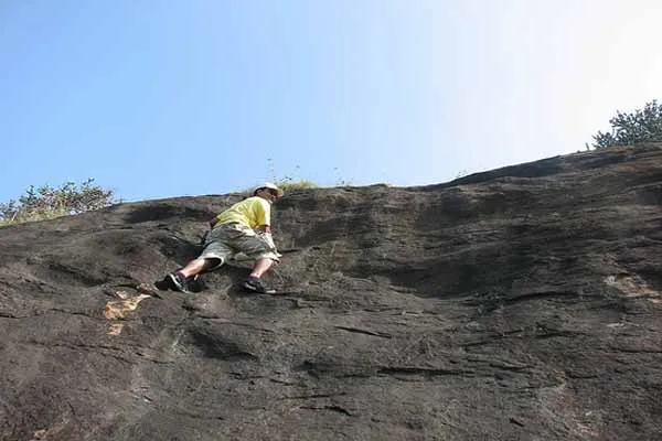
Ramanagaram is not less famous for rock-climbing than its for the bollywood all time favorite movie “shole” which was released some 30+ years back. though nothing really left over as we had seen on screen always. now how it good it could be for trekking. The present town has an Agrahara on the left bank of the Arkavati with a temple of Arkeshwara built in later Vijayanagara style. The temple is said to have been renovated by Krishnaraja Wodeyar III. It is facing west and has a Garbhagriha, a spacious Navaranga and has an inner Prakara.
Things To Carry
- Personal medication (if any)
- One strong backpack
- Water bottles (enough to carry at least 2 liters of water)
- Energy Food (Chocolate bars, flavored milk, Electrolyte drinks - Glucon-D, etc.)
- Small torch with new batteries
- Raincoats, Jackets, Umbrellas (just in case)
- Camera (Optional)
Location info
-
Distances:50km from Bangalore on Bangalore-Mysore highway
-
Camping Sites: Cant camp at the top of the hill.
-
Trek Length: Two to three hours,Day trek, mainly rock climbing, rappeling, etc.
Best time to visit
Any time round the year when its good to trek up the hill
Mobile network coverage
Airtel, Jio, BSNL, and Vi all provide coverage across Karnataka. 4G is reliable in Bangalore, Mysore, Mangalore, Hubli, and along highways. Coverage may be weaker in deep forest areas of Bandipur, Nagarhole, and certain Western Ghats sections. Most hotels, resorts, and cafes in tourist areas offer free Wi-Fi.
Food & restaurants nearby
Food options are available in the nearest town. Karnataka cuisine ranges from coastal seafood to Udupi vegetarian to Coorg’s pandi curry. Dosa, idli, bisi bele bath, and filter coffee are iconic.
Hotels & accommodation nearby
Accommodation is available in the nearest town or city. Options range from budget lodges to luxury resorts. Booking ahead during Dasara (Mysore) and peak winter season is recommended.
Climate & weather
Karnataka has a varied climate from the humid coast to the dry Deccan plateau and cool Western Ghats. The best time to visit is October to March, with temperatures ranging from 15°C to 30°C depending on region. April–May is hot across most of the state (up to 38°C). The southwest monsoon (June–September) brings heavy rain to the coast and ghats but transforms the landscape — this is the best time for Jog Falls and Coorg’s lush greenery. Hill stations (Coorg, Chikmagalur) remain pleasant year-round. Bangalore has a moderate climate throughout.
Helpline & emergency contacts
Tourist Helpline: 1364 (toll-free, 24×7). Police: 112 (all-India emergency). Ambulance: 108. Women’s Helpline: 1091. Karnataka Police Tourist Helpline: 112.
Nearest petrol pump
Petrol pumps are available in the nearest town or on the approach road — check locally for the closest option.
Accessibility
Accessibility information is not currently available for this site. Contact the venue directly or check with your accommodation for the latest accessibility details.
Rules & restrictions
Standard visitor rules apply. Check locally for any specific restrictions at this site.
Best photography spots
The best photography spots are typically during the golden hours (early morning and late afternoon). Scout the location first to identify the best angles, and consider the direction of light at different times of day.
How to reach Ramanagaram
Ramanagaram is accessible from the nearest town via road. The trek starting point is typically 30-60 minutes from the nearest town by local transport. Karnataka is well-connected by air (Kempegowda International Airport Bangalore, Mangalore International Airport, Hubli Airport), rail (extensive network with major junctions at Bangalore, Mysore, Hubli, Mangalore), and road (NH 44, NH 48, NH 75, NH 66). State buses (KSRTC) and private operators connect all towns regularly.
Timings & opening hours
Start trek early morning, ideally by 6:00-7:00 AM. Treks typically take 3-6 hours depending on route and fitness level. Descend before dark (by 5:00-6:00 PM). Night trekking requires guide and permits.
Entry fee & tickets
Entry fee of INR 20-100 per person for forest areas. Some treks in wildlife sanctuaries or national parks require permit fees of INR 200-500. Guide fees (mandatory for certain forest treks): INR 500-1500 per group.
Duration needed
Half day (3-5 hours) for moderate treks. Full day (6-8 hours) for challenging treks. Overnight camping treks are available at select locations.
Safety tips
Never trek alone — always go with a group or guide. Carry sufficient water (3-4 litres per person). Inform someone about your trek plan and expected return time. Mobile network is unavailable in many forest areas. Watch for wildlife (elephants, gaur, leopards) in forest areas. Avoid trekking during heavy rain.
Nearby visiting places
Other trekking peaks, waterfalls, valleys, viewpoints, wildlife sanctuaries, coffee estates, and pilgrimage sites in the surrounding forest area.
Nearest airport, railway & bus
Nearest railway station in the district headquarters town. Nearest airport: typically Kempegowda International Airport Bangalore or Mangalore International Airport. Local buses and taxis connect to the trek base point.
History of Ramanagaram
Ramanagaram is a popular trekking destination in Karnataka, located in the Western Ghats mountain range. The Western Ghats are one of the world’s eight hottest biodiversity hotspots and a UNESCO World Heritage Site, with forests that are millions of years old. Karnataka’s trekking trails range from gentle hills to challenging peaks reaching 1,800+ metres, offering trekkers a chance to experience pristine tropical forests, waterfalls, and panoramic views.
Things to do at Ramanagaram
Trekking through forest trails, reaching summit viewpoints for panoramic vistas, birdwatching and wildlife spotting, photography, camping overnight at designated sites, and stream/river crossings during the trek.
Things to visit & highlights
Summit viewpoints, dense forests, mountain streams and waterfalls, rock formations, valley views, coffee and spice plantations at the foothills, and biodiversity hotspots along the trail.
Frequently asked questions
Q: How difficult is the trek at Ramanagaram? A: Difficulty varies from easy to moderate. Check locally for current trail conditions. Q: Do I need a guide? A: A guide is recommended for first-time visitors and mandatory for certain forest treks. Q: What fitness level is required? A: Moderate fitness is sufficient for most treks. Regular walking exercise helps prepare.
Quick facts
- Type: Tourist Attraction
- State: Karnataka
- Category: Trekking
Visitor information
Please check locally for current visitor information.
Map & location view
This section is being updated and will be available shortly.
Photo gallery of Ramanagaram
Video gallery
Related destinations
Amedikallu
Amedikallu is one of the notable places to visit in Karnataka.

Agumbe Trek
Agumbe, at an altitude 826 M, is a small village in the Shimoga district. This is the same enthralling location which offered an idyllic setting for R.K Narayan's…
Amedikallu
Bangalore -Nelamangala-Kunigal-Channarayapatana-Hassan-Sakaleshpura-Shiradi-Kokkada-Dharmasthala