MOTOSHARE 🚗🏍️
Rent Bikes & Cars Directly from Owners
Motoshare connects vehicle owners with people who need bikes and cars on rent. Owners earn from idle vehicles, and renters get flexible ride options.
Visit Motoshare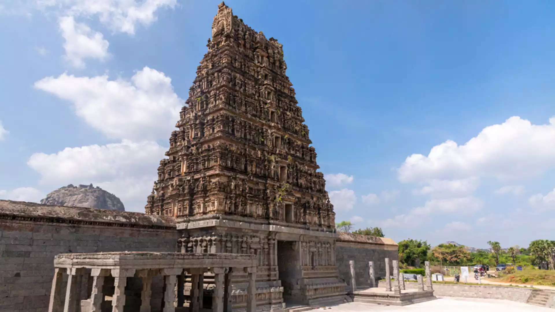
About Villupuram
Villupuram, the second-largest district in Tamil Nadu, is located along the National Highway connecting Chennai and Tiruchirapalli. Established on September 30, 1993, after splitting from South Arcot, Villupuram serves as a crucial transportation hub with well-connected rail and road networks, making it easily accessible from all parts of Tamil Nadu and beyond. The district is home to numerous temples, mosques, churches, and historical monuments, showcasing its rich cultural heritage.
Exploring Villupuram District: A Cultural and Historical Overview
Summarized table highlighting the key points about Villupuram District:
| Aspect | Details |
|---|---|
| Location | Villupuram, Tamil Nadu, India; along NH-45 between Chennai and Tiruchirapalli |
| Establishment | Established on September 30, 1993; separated from South Arcot District |
| Geographical Boundaries | East: Bay of Bengal; South: South Arcot; West: Salem and Dharmapuri; North: Chengalpattu and Tiruvannamalai |
| Climate | Hot and humid; monsoon from October to December; peak summer temperatures up to 42°C |
| Historical Background | Early rule by Cholas, Pallavas, Vijayanagar Empire, British East India Company; notable battles during Anglo-French rivalry |
| Major Attractions | Gingee Fort, Kalyana Mahal, Thiruvaamathoor Temple, Singavaram Ranganatha Temple, Auroville, Kalrayan Hills, Melmalayanur Angala Parameswari Temple |
| Educational Institutions | Colleges: Arignar Anna Govt. Arts College, University College of Engineering, IFET College of Engineering, and others |
| Cultural Heritage | Rich Tamil culture with Hinduism, Christianity, and Islam practiced widely; key festivals include Pongal and Kandhoori |
| Popular Local Foods | Villupuram Upma, Vadacurry, Koozh, Paruppu Payasam, Chettinad dishes, Adhirasam, and traditional filter coffee |
| Emergency Contacts | Police: 100; Fire: 101; Ambulance: 102; Disaster Helpline: 1077; Child Helpline: 1098; Drinking Water Helpline: 1800-425-3566 |
| Transport Options | Rail: Villupuram Junction connects to major cities; Air: Closest airports are in Puducherry (40 km) and Chennai (155 km); Road: NH-45 |
| Accommodation | Grand Kubera, KVR Guest House, Devibala Residency, various hotels in Puducherry for upscale options |
| Local Markets and Crafts | Known for traditional handicrafts, Chettinad jewelry, textiles, and Athangudi tiles |
| Best Time to Visit | October to March (pleasant weather and post-monsoon greenery) |
Historical Significance

Villupuram’s history intertwines with that of South Arcot, with early rule by the Chola dynasty. The region later saw influence from the Pallavas, the powerful Chola Empire, and eventually, the Pandyas. Villupuram then experienced Muslim dominance until the Vijayanagar Kingdom took over in 1378. Historical records mention Shivaji’s conquests in Gingee with the help of the Golconda forces, marking a significant period for Villupuram.
During British rule, Villupuram saw intense conflict as the English and French vied for control, turning it into a battleground. Post-independence, Villupuram retained much of its historical charm and significance, now preserved through its many historical structures.
Climate
Villupuram experiences a hot and humid climate with temperatures soaring up to 42°C in the summer. The monsoon season from October to December brings much-needed rainfall, while winters offer more moderate temperatures ranging from 30-35°C.
Agricultural and Mineral Resources
The district boasts a diverse agricultural output, producing cereals such as paddy, ragi, and various pulses. Commercial crops like groundnut, sugarcane, and bananas also thrive here. The district is rich in mineral deposits, with black granite near Tindivanam and iron ore along the Pennar River in Kallakkurichi Taluk.
Tourist Attractions in Villupuram
The top tourist attractions in Villupuram, each offering a glimpse into the district’s rich history, architectural marvels, and cultural vibrance.
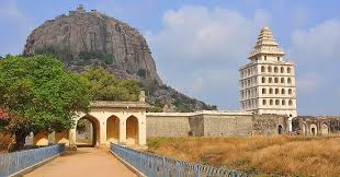
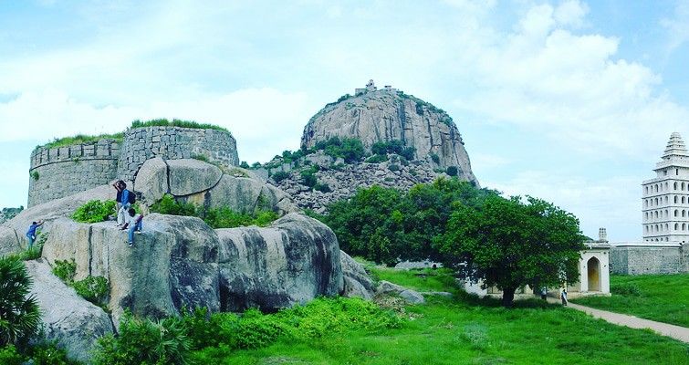
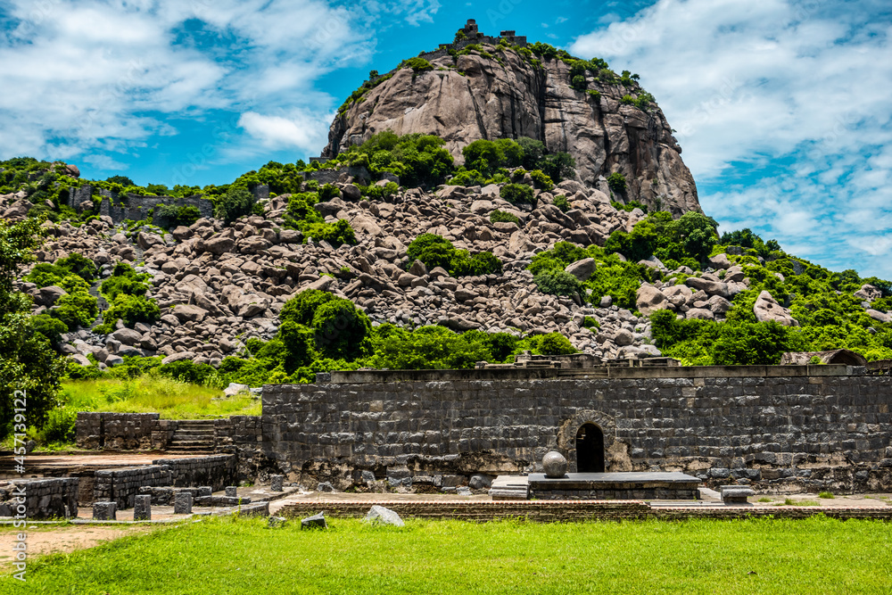
1. Gingee Fort
- Description: Known as the “Troy of the East,” Gingee Fort is a majestic fort complex set atop three hills, connected by massive walls. Built in the 9th century and later fortified by the Vijayanagar rulers, the fort includes citadels, granaries, temples, and ponds, all of which offer a journey through time.
- Key Highlights: Kalyana Mahal, Rajagiri Citadel, and Venugopala Swamy Temple.
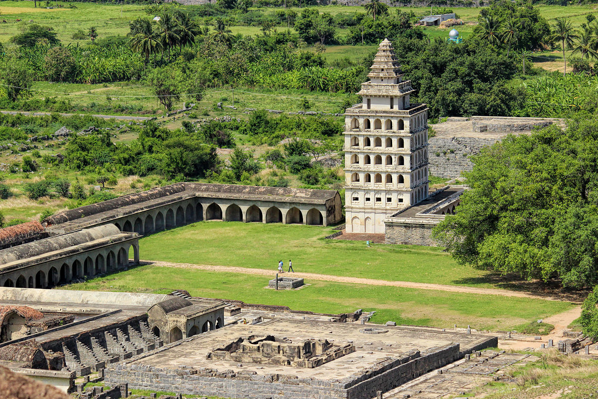
2. Kalyana Mahal
- Description: Located within the Gingee Fort complex, the Kalyana Mahal features Indo-Islamic architecture with a beautiful pyramidal tower, surrounded by rooms for the ladies of the royal household.
- Key Highlights: Square tower and central courtyard, a notable piece of architectural elegance within the fort.
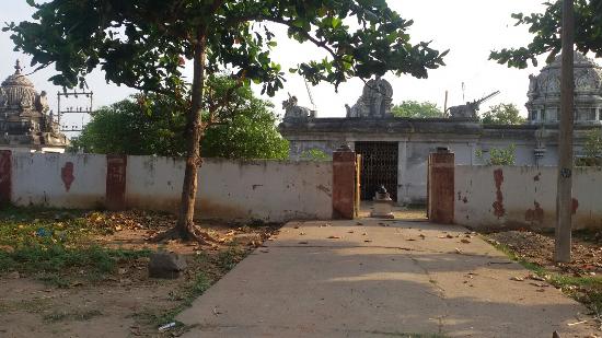
3. Thiruvaamathoor Temple
- Description: This ancient Chola temple is dedicated to Lord Abhirameshwarar. With its remarkable architecture dating back over 1,500 years, the temple is a peaceful place of worship and historical significance.
- Key Highlights: Ornate pillars, intricate stone carvings, and spacious sanctum.
4. Singavaram Ranganatha Temple
- Description: Perched on a hill, this rock-cut temple dedicated to Lord Ranganatha features a large reclining idol. The temple is the royal deity site of the Gingee rulers and offers panoramic views of the surrounding landscape.
- Key Highlights: The 24-foot-long idol of Ranganatha carved from a single rock.
5. Auroville
- Description: Located near Villupuram in Tamil Nadu, Auroville is an international township dedicated to sustainable living, spiritual growth, and unity. It was founded by the Mother of the Sri Aurobindo Ashram in 1968.
- Key Highlights: Matrimandir, Visitors’ Centre, and various eco-friendly settlements, all designed with a focus on sustainability.
6. Kalrayan Hills
- Description: Often called the “Poor Man’s Hill Station” of Tamil Nadu, Kalrayan Hills is perfect for nature lovers and trekkers, with scenic waterfalls, rivers, and a diverse range of flora and fauna.
- Key Highlights: Waterfalls, trekking trails, and panoramic views, especially beautiful during the monsoon season.
7. Melmalayanur Angala Parameswari Temple
- Description: Located 32 km from Gingee, this temple is famous for its unique new moon rituals and the congregation of devotees from across Tamil Nadu. It is dedicated to Angala Parameswari, a powerful local deity.
- Key Highlights: Monthly new moon rituals, vibrant local festivals, and cultural significance.
8. Venugopala Swamy Temple
- Description: Situated within the Gingee Fort complex, this temple houses a sculpture of Lord Krishna playing the flute with his consorts. It is known for its exquisite stone sculptures and serene atmosphere.
- Key Highlights: Intricate stone carvings, spacious courtyard, and serene ambiance.
9. Thirunarungondai Jaina Temple
- Description: Located near Ulundurpet, this ancient temple dedicated to Parsvanatha and Chandraprabha showcases Jain architecture with stunning carvings and sculptures. It’s an important pilgrimage site for Jains.
- Key Highlights: Bronze images, Jain inscriptions, and annual festival celebrated in January-February.
10. Mayilam Subramanya Swamy Temple
- Description: This temple dedicated to Lord Murugan is located on a small hill near Villupuram. The temple attracts a large number of devotees, especially during the Panguni Uthiram festival in March-April.
- Key Highlights: Panoramic views of the surrounding plains, vibrant festivals, and sacred Murugan shrines.
11. Thiruvakkarai Fossil Park
- Description: About 40 km from Villupuram, Thiruvakkarai Fossil Park is a national geological park showcasing petrified tree trunks that date back millions of years. The park also includes a historic temple dedicated to Lord Shiva.
- Key Highlights: Fossilized tree trunks, scenic natural trails, and the Chandramoulisvarar Temple with its elaborate sculptures.
Educational Institutions
Villupuram hosts a variety of educational institutions, from arts and science colleges to engineering and nursing schools. Some notable institutions include:
- Arignar Anna Government Arts College
- University College of Engineering, Villupuram
- I.F.E.T. College of Engineering
- E.S. College of Nursing
Culture and Festivals
Villupuram has a vibrant culture, influenced by neighboring Kerala. Key festivals include Pongal, a significant harvest festival, and Kandhoori, a December celebration that draws people from across Tamil Nadu. Christianity, Hinduism, and Islam are widely practiced in the district, with a blend of Tamil and Kerala cultural traditions.
Travel Information
- Nearest Railway Station: Villupuram Junction, a major railway hub connecting to Chennai and southern Tamil Nadu.
- Nearest Airports: Puducherry Airport (40 km), Chennai International Airport (155 km), and Tiruchirapalli Airport (160 km).
- Road Transport: The district is well-connected via two major national highways, NH-45 and NH-66, making travel by road convenient.
Accommodation Options
Where to Stay in Villupuram: Accommodation Options for Every Traveler
When visiting Villupuram, a district rich in history and culture, you’ll find a variety of accommodation options that cater to different budgets and preferences. Whether you’re looking for a comfortable stay with modern amenities or a budget-friendly guesthouse, Villupuram has something for everyone. Here are some top picks:
1. Grand Kubera
- Location: 716 Nehruji Road, Maghalakshmi Plaza, Villupuram
- Highlights: Known for its comfortable rooms and modern facilities, Grand Kubera offers a quality stay for travelers. With well-furnished interiors and convenient amenities, it’s a popular choice among both business and leisure visitors.
2. KVR Guest House
- Location: Shanmugapuram Colony, West 10 Chairman, Chidambaram Street, Villupuram
- Highlights: KVR Guest House provides clean, simple rooms at affordable rates, making it a budget-friendly option for visitors. Its location near key areas in Villupuram makes it easy for guests to explore the city’s attractions.
3. Park Hotel
- Location: Multiple locations in Villupuram
- Highlights: With comfortable, well-maintained rooms, the Park Hotel offers a pleasant stay with essential amenities like free Wi-Fi and air conditioning. It’s ideally located for travelers looking to explore Villupuram’s historic and cultural sites.
4. Devibala Residency
- Location: Trichy Trunk Road, Opposite Bus Stand, Villupuram
- Highlights: Devibala Residency provides comfortable lodging with all the basics for a satisfying stay. Its location near the bus stand makes it a convenient choice for those relying on public transportation to explore the area.
Must-Try Local Foods in Villupuram: A Taste of Tamil Nadu’s Authentic Flavors
Villupuram, a district steeped in Tamil Nadu’s rich history and culture, also boasts an incredible culinary scene. The local food here is a delicious reflection of the region’s heritage, with dishes that are both comforting and flavorful. Here’s a guide to some of Villupuram’s must-try authentic dishes.
1. Villupuram Upma
- About: A local twist on the classic South Indian upma, this dish is made from roasted semolina (rava) and cooked with mustard seeds, curry leaves, chana dal, and a hint of asafoetida. Villupuram Upma is a light yet flavorful breakfast dish that pairs perfectly with coconut chutney.
- Try It With: A side of tangy tomato or coconut chutney to enhance the flavors.
2. Vadacurry (Vadakari)
- About: Known for its bold spices, Vadacurry is a savory curry made with lentil fritters that are simmered in a spicy tomato and coconut-based gravy. This dish originated as a breakfast staple but is now enjoyed anytime with idli, dosa, or rice.
- Best Paired With: Steamed idli or dosa, making for a hearty meal with a mix of textures.
3. Koozh (Millet Porridge)
- About: Koozh is a traditional Tamil Nadu porridge made from fermented millet flour. This dish is cherished for its cooling properties and is especially popular during summer. Often served with pickles or raw onions, Koozh is a refreshing and nutritious meal option.
- Why It’s Loved: Known for its health benefits, Koozh is also filling and offers a unique taste that is both mildly sour and earthy.
4. Paruppu Payasam
- About: A quintessential Tamil Nadu dessert, Paruppu Payasam is made with split yellow moong dal, jaggery, and coconut milk. Simmered to a sweet perfection, this dish is typically enjoyed during festivals and special occasions.
- Flavor Profile: The sweetness of jaggery blends beautifully with the creamy coconut milk, creating a rich, traditional treat.
5. Chettinad Cuisine Specialties
- About: Villupuram has a strong influence of Chettinad cuisine, renowned for its aromatic spices and bold flavors. Signature dishes like Chettinad Chicken Curry and Pepper Mutton are local favorites, known for their spicy kick and complex seasoning.
- Best Served With: Steamed rice or parottas, the spicy gravies make for a perfect pairing with these local staples.
6. Traditional Tamil Nadu Sweets
- About: Villupuram’s sweet offerings are as delightful as its savory dishes. Try Adhirasam, a sweet deep-fried delicacy made with rice flour and jaggery, or Pori Urundai, puffed rice balls bound with jaggery. These sweets are an integral part of Tamil Nadu’s festive celebrations.
- Why You’ll Love It: These sweets are rich in flavor, with a delightful crunch and a satisfying sweetness, making them perfect for dessert or a snack.
7. Filter Coffee
- About: End your meal with a quintessential Tamil Nadu filter coffee. Brewed with a traditional metal filter, this coffee is strong, aromatic, and served in a stainless steel tumbler and dabarah.
- Experience: The robust coffee, brewed with chicory, provides a perfect end to any meal with its rich and invigorating taste.
Additional Tips for Visiting Villupuram: Make the Most of Your Trip
Exploring Villupuram can be a rewarding experience with its historical landmarks, vibrant local culture, and delicious food. Here are some handy tips to help you enjoy your visit to this fascinating district:
1. Best Time to Visit
- Optimal Season: Plan your trip between October and March to avoid the summer heat. This period offers pleasant weather, making it ideal for sightseeing and outdoor activities.
- Monsoon Note: While the monsoon season (October to December) brings refreshing rains, it can also lead to unexpected road closures in some rural areas.
2. Stay Hydrated and Cool
- Hot Climate: Villupuram has a hot, humid climate, especially during the summer months, so remember to carry water and stay hydrated.
- Sun Protection: Bring sunscreen, hats, and sunglasses, especially if you’re visiting open spaces like Gingee Fort or local temples.
3. Dress Modestly
- Respect Local Culture: Tamil Nadu is culturally rich, and many of its sites, especially temples, require modest attire. Wearing clothing that covers your shoulders and knees is recommended.
- Footwear for Temples: Some temples require visitors to remove their shoes before entering, so consider wearing easy-to-slip-off shoes for convenience.
4. Try Local Cuisine Safely
- Explore Food Safely: While Villupuram’s local cuisine is delicious, if you’re not used to spicy food, ask for milder versions, especially in Chettinad dishes.
- Bottled Water: Stick to bottled or filtered water to avoid any digestive discomfort, especially in rural areas.
5. Transportation Tips
- Local Transport: Villupuram has a well-connected bus and train network, but having your own vehicle or hiring a cab can offer more flexibility, especially if you plan to visit off-the-beaten-path locations like Kalrayan Hills.
- Railway Hub: Villupuram Junction is a major railway hub. If you’re traveling from another part of Tamil Nadu or India, check train availability to Villupuram for a convenient journey.
6. Respect Historic Sites
- Preserve the Heritage: Villupuram’s attractions, like Gingee Fort, have survived centuries. Avoid touching delicate carvings and sculptures, and stay within designated areas to help preserve these landmarks.
- Photography Etiquette: Some temples may have restrictions on photography, so check for signs or ask permission before taking pictures, especially in religious areas.
7. Visit Local Markets for Souvenirs
- Handcrafted Goods: Villupuram offers a range of traditional handicrafts, Chettinad-inspired jewelry, and textiles. Local markets are a great place to find unique items and support local artisans.
8. Learn a Few Tamil Phrases
- Language Tip: While English is spoken in tourist areas, learning a few Tamil phrases can enhance your interactions with locals and show respect for the culture.
9. Plan for Limited Facilities in Rural Areas
- Facilities: Some rural attractions may not have access to basic amenities, so carry essentials like snacks, water, and hand sanitizers if you’re heading out on day trips.
10. Engage with the Locals
- Local Insights: Tamil Nadu locals are known for their hospitality. Engaging with locals, whether it’s at a market or a tea shop, can offer valuable insights into the area’s culture and hidden gems.
Essential Emergency Contacts for Villupuram: Stay Safe While You Explore
Detailed Breakdown of Services
- State and Collectorate Control Rooms
- State Control Room (1070): For general emergency assistance.
- Collectorate Control Room (04146-223265): Managed by the Villupuram District Collectorate, this helpline can provide administrative assistance and address urgent issues related to district services.
- Police Control Room (100)
- In case of theft, accidents, or any law-and-order situations, the Police Control Room ensures immediate response and security assistance.
- Medical Assistance
- Ambulance Services (102): For medical emergencies, dial 102 for a quick response.
- Accident Helpline (108): Specifically for road accidents or serious injuries requiring urgent medical care.
- Fire and Rescue Services (101)
- Villupuram has multiple fire stations. In case of fire or any other rescue-related incidents, the Fire and Rescue service is prompt and equipped to handle emergencies.
- Child Helpline (1098)
- If you encounter a child in need, especially in cases of abuse or exploitation, this helpline provides assistance in coordination with child protection agencies.
- Disaster Management Helpline (1077)
- Tamil Nadu’s Disaster Management Helpline assists with natural calamities, such as floods, cyclones, or earthquakes, offering timely evacuation and relief support.
- Sexual Harassment Helpline (1091)
- A helpline dedicated to supporting women in distress or facing harassment. Managed by the state, this number ensures assistance and guidance.
- Drinking Water and Aadhaar Helplines
- Drinking Water (1800-425-3566): For issues related to drinking water supply, such as shortages or quality concerns.
- Aadhaar Helpline (1947): Assistance for Aadhaar card-related queries and support.
Conclusion
Villupuram is a district with deep-rooted cultural, historical, and natural beauty. From majestic forts to ancient temples, fertile lands, and mineral-rich terrain, Villupuram offers a diverse experience for travelers looking to explore Tamil Nadu’s historical heart. With its well-connected roads and railways, rich cultural heritage, and historical sites, Villupuram stands as a must-visit destination in Tamil Nadu.
Image Gallery of Villupuram Districts
Video Link

I am a passionate traveler, city explorer, and digital publisher focused on documenting real journeys, local cultures, and everyday travel experiences across India and beyond. Through my platforms, I share practical travel guides, city blogs, and daily travel logs that help readers explore destinations with confidence and local insight.
I am the creator of HolidayLandmark, a travel-focused ecosystem covering destinations, stories, and experiences through blogs, social platforms, and curated travel content:
Instagram – HolidayLandmark
Facebook – HolidayLandmark
YouTube – HolidayLandmark
LinkedIn – HolidayLandmark
X (Twitter) – HolidayLandmark
HolidayLandmark on Blogger
HolidayLandmark on WordPress
HolidayLandmark Stories
Alongside HolidayLandmark, I manage multiple city-focused travel portals where I publish daily travel logs and in-depth city blogs covering local attractions, food, culture, and real traveler experiences:
City Daily Travel Logs
Bangalore Orbit – Daily Logs
Bhopal Orbit – Daily Logs
Chennai Orbit – Daily Logs
Gujarat Orbit – Daily Logs
Kerala Orbit – Daily Logs
Mera Apna Bihar – Daily Logs
Mumbai Orbit – Daily Logs
City Blogs & Travel Guides
Bangalore Orbit – Blog
Bhopal Orbit – Blog
Chennai Orbit – Blog
Gujarat Orbit – Blog
Kerala Orbit – Blog
Mera Apna Bihar – Blog
Mumbai Orbit – Blog
Through these platforms, my goal is to create a connected travel network that offers reliable city information, real-time travel experiences, and practical guidance for travelers, explorers, and local enthusiasts.
22.06.2026 VILLUPURAM
Tourist Payment Charge Rupees and COINS