MOTOSHARE 🚗🏍️
Rent Bikes & Cars Directly from Owners
Motoshare connects vehicle owners with people who need bikes and cars on rent. Owners earn from idle vehicles, and renters get flexible ride options.
Visit MotoshareBangalore’s Elevation – A Breakdown of Key Areas
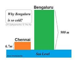
Bangalore, located in the southern part of India, is known for its relatively higher elevation compared to other metropolitan cities. The city sits on the Deccan Plateau and its elevation provides a moderate climate throughout the year. Below is a breakdown of the central, residential, commercial, northern, and southern areas of Bangalore, along with their elevations:
Here are the approximate elevations of different parts of Bangalore, India, measured from sea level:
- Central Business District (CBD) and surrounding areas:
- MG Road: Around 920 meters (3,018 feet) above sea level.
- Brigade Road: Around 930 meters (3,051 feet) above sea level.
- Vidhana Soudha: Around 920 meters (3,018 feet) above sea level.
- Cubbon Park: Around 930 meters (3,051 feet) above sea level.
- Residential and Commercial Areas:
- Indiranagar: Around 920 meters (3,018 feet) above sea level.
- Koramangala: Around 920 meters (3,018 feet) above sea level.
- Jayanagar: Around 920 meters (3,018 feet) above sea level.
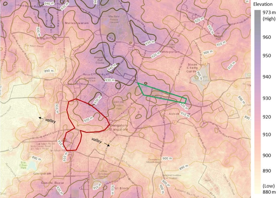
- Malleswaram: Around 920 meters (3,018 feet) above sea level.
- Rajajinagar: Around 920 meters (3,018 feet) above sea level.
- Northern and Southern Parts:
- Yelahanka: Around 920 meters (3,018 feet) above sea level.
- Hebbal: Around 920 meters (3,018 feet) above sea level.
- Electronic City: Around 890 meters (2,920 feet) above sea level.
- Bannerghatta Road: Around 890 meters (2,920 feet) above sea level.
Central Business District (CBD) and Surrounding Areas:
- MG Road:
- Elevation: Around 920 meters (3,018 feet) above sea level.
- Overview: MG Road is one of Bangalore’s busiest and most prominent streets, home to several commercial establishments, retail outlets, restaurants, and pubs. It is a key artery of the city and well-known for its vibrancy and nightlife.
- Brigade Road:
- Elevation: Around 930 meters (3,051 feet) above sea level.
- Overview: Brigade Road is adjacent to MG Road and serves as a major shopping and commercial hub. Popular for its high-end stores and street shopping options, this area attracts locals and tourists alike.
- Vidhana Soudha:
- Elevation: Around 920 meters (3,018 feet) above sea level.
- Overview: Vidhana Soudha, the seat of Karnataka’s legislative assembly, is a grand building known for its majestic architecture. Situated in the heart of the city, it is surrounded by important government offices and landmarks.
- Cubbon Park:
- Elevation: Around 930 meters (3,051 feet) above sea level.
- Overview: Cubbon Park is a massive green space in the center of Bangalore, offering a natural retreat amidst the bustling city. It is a favorite for morning joggers, nature enthusiasts, and those looking to relax outdoors.
Residential and Commercial Areas:
- Indiranagar:
- Elevation: Around 920 meters (3,018 feet) above sea level.
- Overview: Indiranagar is a high-end residential and commercial neighborhood known for its upscale restaurants, pubs, cafes, and boutiques. It has grown into a popular area for nightlife and shopping.
- Koramangala:
- Elevation: Around 920 meters (3,018 feet) above sea level.
- Overview: Koramangala is a well-known locality that blends residential and commercial spaces. It is a hub for tech companies, startups, cafes, and shopping malls. Its central location makes it a popular area for young professionals and families alike.
- Jayanagar:
- Elevation: Around 920 meters (3,018 feet) above sea level.
- Overview: Jayanagar is one of Bangalore’s older residential areas, featuring broad streets, parks, and temples. It has a mix of traditional homes and modern buildings, making it a preferred location for families.
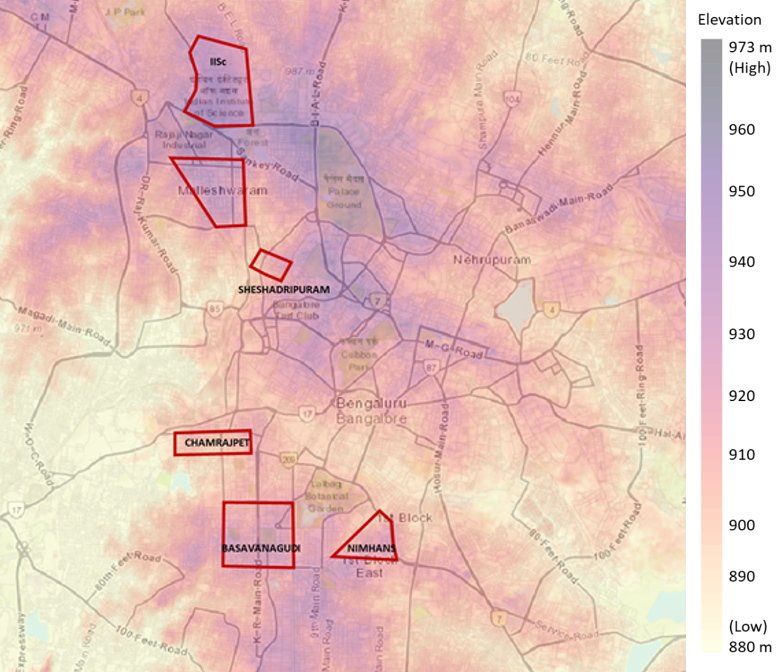
- Malleswaram:
- Elevation: Around 920 meters (3,018 feet) above sea level.
- Overview: Malleswaram is a traditional residential area known for its cultural heritage, temples, and local markets. It is a serene neighborhood offering a mix of old Bangalore charm with modern conveniences.
- Rajajinagar:
- Elevation: Around 920 meters (3,018 feet) above sea level.
- Overview: Rajajinagar is a prominent residential and industrial locality in West Bangalore. It has a mix of residential blocks, educational institutions, and commercial establishments.
Northern and Southern Parts:
- Yelahanka:
- Elevation: Around 920 meters (3,018 feet) above sea level.
- Overview: Yelahanka is a rapidly growing suburb in North Bangalore. Initially known for its Air Force base, it has developed into a significant residential and industrial area with many tech parks and educational institutions.
- Hebbal:
- Elevation: Around 920 meters (3,018 feet) above sea level.
- Overview: Hebbal is well-known for its lake, flyover, and the IT parks that have sprung up in recent years. The area connects the central parts of Bangalore with the airport and is seeing significant real estate development.
- Electronic City:
- Elevation: Around 890 meters (2,920 feet) above sea level.
- Overview: Located in South Bangalore, Electronic City is one of India’s largest industrial and technology hubs. It is home to major IT companies and a large number of tech professionals. The lower elevation compared to central Bangalore makes its climate slightly warmer.
- Bannerghatta Road:
- Elevation: Around 890 meters (2,920 feet) above sea level.
- Overview: Bannerghatta Road is famous for the Bannerghatta National Park, but it has also developed into a bustling residential and commercial area. The road is lined with educational institutions, hospitals, and shopping centers, making it a vibrant part of South Bangalore.
Conclusion:
Bangalore’s elevation plays a crucial role in shaping its pleasant climate. Most of the city’s prominent areas, including the Central Business District (CBD), residential zones like Indiranagar and Jayanagar, and industrial hubs like Yelahanka and Hebbal, are situated around 920 meters above sea level. The southern parts like Electronic City and Bannerghatta Road have a slightly lower elevation of 890 meters. These consistent elevations across Bangalore make the city known for its mild weather, with cooler temperatures compared to many other Indian cities.

I am a passionate traveler, city explorer, and digital publisher focused on documenting real journeys, local cultures, and everyday travel experiences across India and beyond. Through my platforms, I share practical travel guides, city blogs, and daily travel logs that help readers explore destinations with confidence and local insight.
I am the creator of HolidayLandmark, a travel-focused ecosystem covering destinations, stories, and experiences through blogs, social platforms, and curated travel content:
Instagram – HolidayLandmark
Facebook – HolidayLandmark
YouTube – HolidayLandmark
LinkedIn – HolidayLandmark
X (Twitter) – HolidayLandmark
HolidayLandmark on Blogger
HolidayLandmark on WordPress
HolidayLandmark Stories
Alongside HolidayLandmark, I manage multiple city-focused travel portals where I publish daily travel logs and in-depth city blogs covering local attractions, food, culture, and real traveler experiences:
City Daily Travel Logs
Bangalore Orbit – Daily Logs
Bhopal Orbit – Daily Logs
Chennai Orbit – Daily Logs
Gujarat Orbit – Daily Logs
Kerala Orbit – Daily Logs
Mera Apna Bihar – Daily Logs
Mumbai Orbit – Daily Logs
City Blogs & Travel Guides
Bangalore Orbit – Blog
Bhopal Orbit – Blog
Chennai Orbit – Blog
Gujarat Orbit – Blog
Kerala Orbit – Blog
Mera Apna Bihar – Blog
Mumbai Orbit – Blog
Through these platforms, my goal is to create a connected travel network that offers reliable city information, real-time travel experiences, and practical guidance for travelers, explorers, and local enthusiasts.