
Villupuram Districts
Villupuram Districts |
About: |
|
Viluppuram serves as the district headquarters of Viluppuram District, which was established on 30th September 1993, after its bifurcation from the South Arcot District. As the second-largest district in Tamil Nadu, Viluppuram is strategically positioned along the Tiruchirapalli to Chennai National Highway No. 45, providing key road and rail connectivity throughout Tamil Nadu and beyond. The district features a variety of tourist spots over 100 years old, including revered temples, mosques, and churches with rich historical significance. We warmly welcome you to explore the many beautiful and culturally rich tourist destinations in our district. Villupuram is renowned as a prime tourist destination in Tamil Nadu, with notable attractions like the Villupuram Ramaswamy Padaiyatchiar and the majestic Gingee Fort, a rare monument celebrated for its historical grandeur. The district is bordered by the Bay of Bengal to the east, South Arcot to the south, Salem and Dharmapuri districts to the west, and Chengalpattu and Tiruvannamalai districts to the north. Villupuram stands as the administrative center of this region, guiding its development and cultural preservation. The southern trunk road, connecting Chennai to Tiruchirappalli, traverses the district through key towns like Tindivanam, Villupuram, and Ulundurpettai. Additionally, the Ulundurpettai-Attur State Highway, passing through Kallakkurichi Taluk, and the southern railway line between Chennai and Dhanushkodi, which runs via Tindivanam and Villupuram, enhance the district’s accessibility. Branch lines also connect Villupuram to Katpadi and Pondicherry, making it a significant junction for travelers. Viluppuram District is endowed with substantial mineral resources, including Cretaceous limestone deposits near Thirunakkanai, alluvial beds found along the Ponnaiyar, Gadilam, and Gingee rivers, and iron ore in limited quantities along the Pennar River in Kallakurichi Taluk. Kunnam, near Tindivanam, is a renowned source of black granite, famous for its polish and exported globally for use in monumental structures and high-quality building materials. The principal cereal crops of this district are paddy, varagu, cholam, cumbu, ragi, etc. Important varieties of pulses are red gram, green gram and black gram. Chief commercial crops of the district are groundnut, sugarcane, gingelly etc. Bananas and mangoes are the important fruits cultivated in the district. The principal rivers that serve the region are the Coleroon, vellar manimukthanaeli and Ponnaiyar. All these rivers flows in valleys an have been harnessed for irrigation purposes by anicuts builds across them at various stages of their course. Tanks are also used for irrigation. |
Location: |
|
Climate/Weather: |
|
History: |
|
Villupuram District has a rich historical legacy that dates back several centuries. Originally part of the larger South Arcot District, Villupuram was established as a separate district on 30th September 1993, marking a new administrative era. The region has been under the rule of several prominent dynasties, including the Cholas, Pallavas, and later, the Vijayanagara Empire, each leaving a distinct cultural and architectural footprint. During the Chola and Pallava periods, Villupuram thrived as a center of art, religion, and architecture, as evidenced by its ancient temples and inscriptions. The Pallavas, in particular, contributed significantly to the construction of intricate rock-cut temples, while the Cholas enhanced the region's cultural richness with their impressive stone temples and sculptures. One of Villupuram's most famous historical sites is the Gingee Fort, a fortress with origins dating back to the Chola dynasty, which was later fortified by the Vijayanagara rulers and then further by the Marathas and the French. Known as the “Troy of the East,” this fort is an architectural marvel with its strategic design and has withstood numerous battles over centuries. In the colonial era, Villupuram was a focal point of activity for both the British and the French, due to its proximity to Pondicherry, a French colony. The district's rail and road infrastructure was significantly developed during this period, cementing its role as a transport hub in Tamil Nadu. Today, Villupuram District retains its historical significance, with heritage sites and ancient temples drawing visitors and scholars interested in exploring its vibrant past and well-preserved architectural treasures. |
Educational Institutions: |
|
Villupuram District is home to a diverse range of educational institutions, offering quality education across various levels and fields. The district has made significant strides in improving literacy rates and access to education, with numerous schools, colleges, and vocational training centers available to students.
These institutions play a crucial role in the educational development of Villupuram, providing students with opportunities for higher education and skill development, and contributing to the district’s growth and workforce development. |
Language: |
|
The primary language spoken in Villupuram District is Tamil, which is also the official language of the state of Tamil Nadu. Tamil is widely used in all aspects of daily life, including education, government, and commerce. Most residents speak Tamil fluently, and it is the medium of instruction in schools and colleges. In addition to Tamil, a small percentage of the population also understands and speaks English, especially in urban areas and among the younger generation, professionals, and students. English is commonly used in educational institutions and in business settings where interaction with people from other regions is required. Due to its proximity to neighboring states, some residents may also have a basic understanding of Telugu and Kannada. However, Tamil remains the dominant language that unites the community culturally and socially across Villupuram. |
Culture: |
|
Villupuram District boasts a rich and vibrant culture rooted in Tamil traditions, which are reflected in its festivals, art, cuisine, and daily life. The people of Villupuram are known for their warmth, hospitality, and strong connection to their heritage.
Villupuram’s culture is a vibrant blend of tradition and simplicity, which continues to thrive in its festivals, arts, and community life, making it a district with deep cultural roots and a strong sense of identity. |
How to Reach: |
|
Villupuram District is well-connected by road, rail, and air, making it accessible from various parts of Tamil Nadu and other states in India. Here’s how you can reach Villupuram:
With excellent connectivity by road and rail, reaching Villupuram is straightforward, making it a popular destination for tourists and pilgrims alike. |
Tourist Attractions: |
|
Villupuram District is home to a variety of captivating tourist attractions, blending historical, cultural, and natural sites that appeal to a wide range of visitors. Here are some of the district’s highlights:
Villupuram District offers a mix of historical sites, religious landmarks, and natural beauty, making it an enriching destination for tourists of all interests. |
Hotels/Lodges/Accommodation: |
|
Villupuram District offers a range of accommodations to suit different budgets, providing comfortable and convenient options for visitors. Here are some of the popular choices:
Whether you’re looking for budget accommodation or a more luxurious stay, Villupuram District and its surrounding areas have several options to ensure a pleasant experience for all visitors. |
Useful Links: |
|
For more information and resources about Villupuram District, visit the following links:
These links provide reliable information and convenient booking options to help make your visit to Villupuram District memorable and hassle-free. |
Villupuram Districts |
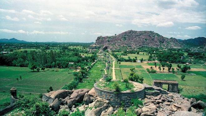
| Gingee Fort: |
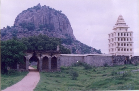
| Nestled on three hills, and enclosed by a huge rampart 60 feet thick, stands the majestic GINGEE Fort, in the Villuppuram district, which is located on the Thindivanam to Thiruvannamalai road about 25 kms from Thindivanam and 130 kms from Chidambaram. The indomitable courage and valour of its erstwhile rulers, caused Father pimenta, a Jesuit priest to call the GINGEE Fort the Troy of the East Besieged by the Mughals and battered by the British, the fort still stands at 800ft. in height, guarded by a moat, eighty feet wide. Much of the early history of this 800Year old fort is shrouded in mystery,as the fort seems to have changed many hands times before it was annexed to the Vijayanagar empire. Gingee is known as GINGEE in Tamil. The small town of GINGEE was once a capital city, With its province extending from Nellore in the north to the Coleroon (Kollidam) in the south. According to local legend, GINGEE Amman, was one of the seven virgins who were the guardian deities of the Village. Legend has it that at around 1200 A. D. , GINGEE was fortified by Ananda Kone, chief of the local shepherd community. In 1240 A. D. Krishna Kone . His successor is said to have fortified the northern hill which later came to be known as krishnagiri.The kone dynasty gave way to the kurumbars, who established their headquarters at Sendamangalam,which later came under the powerful Chola empire. Recorded history goes back to the 16th century, when Gingee (GINGEE) became the seat of the Nayaka rulers, who were under the lordship of the expanding Vijayanagar empire. Krishnadevaraya appointed Krishnappa Nayaka, and he was considered the founder of the Nayaka line of Gingee..............more |
| Fortification Walls: |
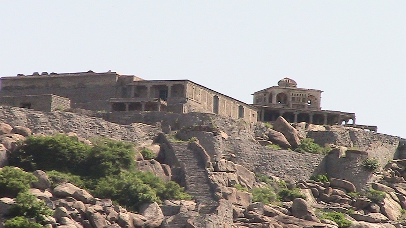
| The massive fortification walls of Gingee interconnect the three inaccessible hills-krishnaglri, chakkilidrug and Rajagiri. The three hills are disported in the form of triangle, while the main wall connecting them is 20 meters thick. The tops of the three hills form impregnable citadels, while the inner fort contains many fortifications and gates. The Rajagiri citadel is the highest, about 800 ft. in height, and the most inaccessible. The 20 meters deep chasm is now connected by a bridge...............more |
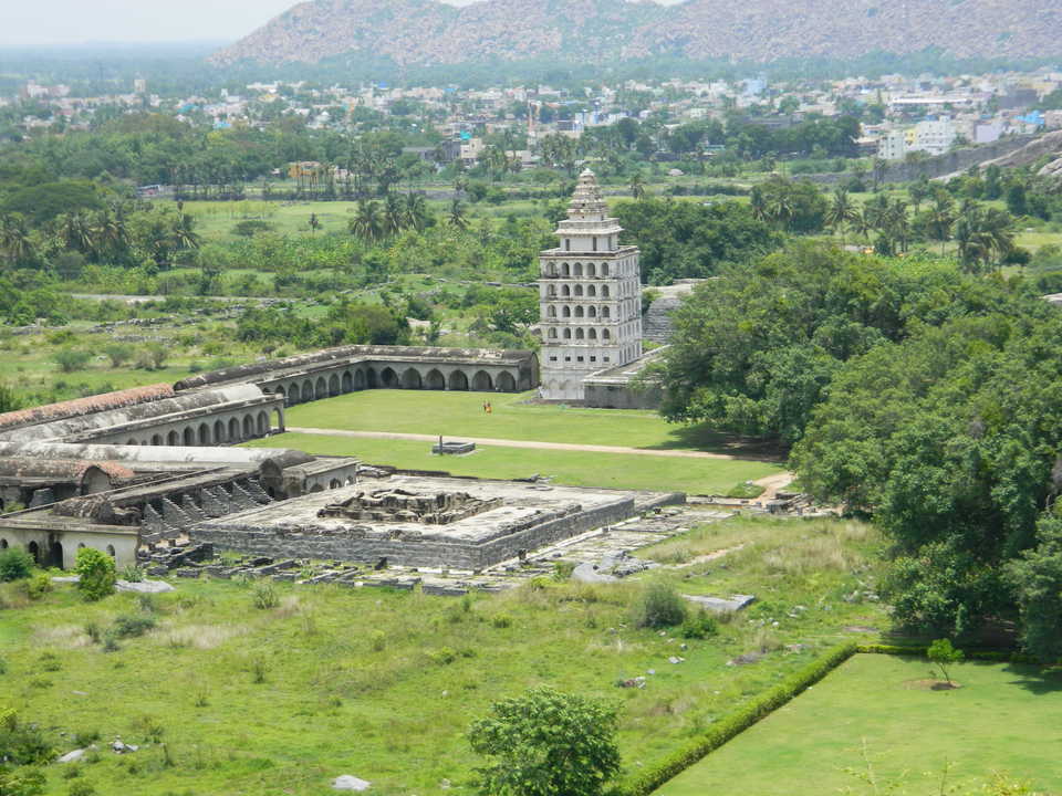
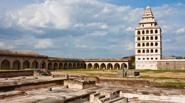
| Kalyana Mahal: |
| Built in the indo-Islamic style, the kalyana Mahal is one of the most attractive ruins in the fort. It consists of a square court, surrounded by rooms for the ladies of the Governors household. In the middle of this court, is a 27 meter high square tower, built of stone. The tower has a pyramidal roof. The rooms in this tower are very similar to other Vijayanagar Nayaka buildings elsewhere................more |
| Venugopala swamy Temple: |
| Located to the west of the inner gate of the lower citadel, the temple contains a remarkable sculpture depicting Lord krishna playing on the flute with is two consorts. Another interesting feature in this temple is a finely polished, broadsmooth slab found in front of the temple.............more |
| The Ponds: |
| The way to the Hanuman Temple, outside the lower fort, abounds in temple ponds and many impressive structures. Chakkarakulam and chettikulam are the two famous ponds in this fort.Chettikulam was built by Raja shetty during the Maratha occupation of the place, towards the end of the 18th century. To the north of this pond is a platform believed to be Raja Desingh funeral pyre, where his young wife committed sati..............more |
| Ranganatha temple: |
| The famous Ranganatha temple.Built in typical Indo-Islamic style, the Audience hall is a damaged roof supported by a series of graceful little pointed arches. The Magazine building is also a noteworthy structure. Built in typical Vijayanagar style, is the famous Rangantha Temple. To the south of the watch-tower, is a big iron cannon, roughly 4 meters long, and 2 meters in circumference. In style and form, this cannon is very similar to the Malik-1-Maidan of Bijapur.............more |
| Sad – at – Ullah Khan Mosque: |
| This mosque was erected by sad – at – Ullah khah to commemorate his victory over De singh and the capture of the fort in 1713 A. D . it is located at the entrance of the inner fort of Rajagiri. According to a Persian inscription found here, the mosque is said to have been constructed in 1717 –1718 A. D.............more |
| Kamalakkanni Amman Temple: |
| This small shrine dedicated to Kamalakkani Amman (Goddess Durga), a local delty, is found on the way to the citadel on Rajagiri Hill. It contains a sacrificial altar and well-preserved mural paintings belonging to the Nayak period.............more |
| Thiruvaamathoor: |
| An ancient Chola temple. Dedicated to lord Sri Abiramaeshwarar is found here. 1500 years old temple . As the temple seems to have changed many hands Times between. Rajaraja Chola I (AD 985-1012) and Seerangadeva Maharayar. (1584.AD) The Amman Named Muththambigai.............more |
| Thumpoor : |
| The Temple of lord Nagamman. This temple is 1450 years old............more |
| Esalam : |
| Built by Rajendra Cholan I (1012) lord sri Ramanatha Eswarar. The legend found in Sanskrit language and in grantha character. Written on the periphery of the seal is as follows, Rajad-Rajanya Makuta sreni-ratnesu sasanam Etad Rajendra Cholasya parakesari varmanah.shrine dedicated to kamalakkani Amman (Goddess Durga), a local deity, is found on the way to the citadel on Rajagiri Hill. It contains a sacrificial altar and well – preserved murul paintings belonging to the Nayak period............more |
| Ennairam: |
| The Chola temple of Narasimma swamy koil Built by Rajaraja Chola 1 (985 –1014). 8,000 samanaras were lived in this village. Another temple Narchimma Perumal Koil found here.............more |
| Thalavanur: |
| Shatru Malleswaralayam – Rock cut temple built by the pallava King Mahendra Varman (B.C.580 to 630). Sculptures and Tamil and Sanskrit inscriptions are found here...........more |
| Pachchaiamman Temple: |
| T his was worshipped by special chittars. 7 Jadamuni shapes are very big pachaimalai is in the back side. Medicine plants are there. This medicine are can’t find Even in the kollimalai. Purathana temple is on the top, no statue on there. We can see the Thiruvannamalai tower standing in the half of the this mountain very clear.............more |
| Theerthangarargul: |
| It is 2 kms north of Gingee town. The hillock on the western side of the road has two jaina caverns and a huge boulder containing sculptures of all the 24 Theerthankaras 9th Century style. It is only place where all the 24 Theerthankaras are shown in a single large composition. A open rock nearby was the place where monk Chandranandi observed 57 days of fasting and died (5th- 6th century A.D) Another monk Ilayabhattara observed 30 days of fasting and died in the Century A.D. The pathway leading to the caves at the ground level has an image of Adinatha and at the top of a figure of Mahavira..............more |
| Melmalayanur: |
| The temple of Angala Parameswari is 32 kms from Gingee, the special deity of the Sembadavars. Here festival occurs in February-March. A special feature of this festival is the Simimasana kollai. The people who attend the festival cook large quantities of grain of various kinds and set them out in the burning ground and offer them to goddess who is brought there. Every Ammavasai (New Moon day) there will be the Lakhs of devotees throng here. situated here. In the inner sanctum there is a snake pit which is being worshipped. There is a congregation of devotees on every new moon day....................more |
| Singavaram : |
| The temple of Lord Ranganatha, the tutelary god of Raja Desingh is on a hill top. It is a good specimen of south Indian type of rock – cut shrine. The idol of Lord Ranganatha, in a reclining posture, measures 24 ft, in length which together with the inner sanctorum, is carved out of a single rock. It is said to be bigger than that of Theidol in Srirangam..............more |
| Venkataramana Temple : |
| This sprawling temple, with its striking sculptures and carved pillars, narrates the aesthetic skills of the Nayaka dynasty. Built by MuthialuNayaka (1540-1550 A. D ) this is the largest temple to GINGEE. The later Vijayanagar period. The temple abounds in gopuras, mandapas and sculptured panels depicting gods and goddesses in scenes from the Hindu epics. Many Tamil inscriptions are also found in the walls of the Mandapas.The temple seems to have faced hard times during the French occupation (after 1761 A .D.) From this period the temple experienced forms of decay and old archaeological wealth was plundered by subsequent invaders.....................more |
| Krishnagiri : |
| This is a small hill made up of granite boulders, located to the north of Rajagiri on the main road from GINGEE to Tiruvannamalai. The citadel on this hill, can be reached by climbing a flight of steps over a steep slope. Within the citadel are two stone-built granaries, a pillared hall, two temples and an edifice built of brick and mortar known as the Audience Chamber.....................more |
| Melnaariyappanoor Church: |
| Melnaariyappanoor Church is the 100 year old famous church is situated in Chennai - Selam highway and 8 km from Chinna Salem. The church is constructed by the Kunchaan, a devotee of St. Anthoniyar...........more |
| Mandagapattu: |
| Mandagapattu is famous archeological Temple site is 20 kms from Viluppuram and 17 kms from Gingee. It is a 100 ft hillock, where the Mahendraverma (I) of Pallava kind, 580-630 made a cave temple...........more |
| Mel Chittamur: |
| Mel Chittamur is which is 20 kms of Thindivanam and 10 kms east of Gingee. Head quarters of Digambara sect in Tamilnadu with the JINAKANCHI MATHA presided over by the Pontiff. Two temples, one dedicated to Parsvanatha and other known as 'Mailanatha temple was originally a boulder containing roc-cut images of Bahubali, Parsvanatha, Adinatha, Mahavira and Ambika yakshi carved in the 9th century AD. Rebuilt in the 16th century and renovated in the present century..........more |
| Thirunarungondai: |
| Thirunarungondai It is 16 kms northwest of Ulundurpet and 21 kms east of Thirukkoilur. Hillock at the village contains a Jaina cave and two temples dedicated to Parsvanatha and Chanraprabha. Cave served as the monastery of the monks of Virasangha in the 8th - 9th century A.D. Rich collection of bronze images found in the temple. Annual festival (Jan-Feb) celebrated on a grand scale and attended by Jains from all over Tamilnadu............more |
| Auroville: |
| Auroville is an international township. This town of tomorrow now in the making - supported and encouraged by the Government of India, and endorsed by UNESCO - is sited just across the Puducherry border in Tamil Nadu. Representing an experiment in international living, it was launched in 1968 at the behest of the Mother of the Sri Aurobindo Ashram at an inaugural function attended by representatives of 124 nations and all the States of India. This "City of Dawn" is still in its initial stages of development, though the Matrimandir, the central building intended for silent concentration, is now functional, as are many other major facilities, such as its Visitors Centre, Town Hall, etc. The near-2000 Auroville residents from some 40 countries live in 100+ scattered settlements spread around the landscape, either in the city area or surrounding Green Belt. The aim of the project is the achievement of an actual human unity in diversity, while at the same time researching into new approaches to education, health care, alternative energy usage, environmental regeneration, and sustainable living in general. Each inhabitant of Auroville contributes in his or her own way towards building the township. For more detailed information see the Auroville website www.auroville.org ............more |
| Thirukkoilur: |
| Thirukkoilur is situated on the Cuddalore - Chittoor trunk road and 37 kms from Viluppuram. the presiding deities of the Vishnu Temple are Ulagalanda Perumal (Thiruvikrama Swami) and Pushpavallithayar. Kabilar Kundru is also yet another picnic spot at Thirukkoilur which is situated in the middle of the river Pennayar. Kabilar was saint here and his last resting place, is maintained by the state Archaeological Department..........more |
| Kalrayan Hills: |
| Kalrayan Hills It is one part of the Eastern ghats, lies on the western side of the Kallakurichi Taluk. This area spread over an area of 600 sq. kms. approximately with the height ranging from 1000 ft to 3800 ft from the sea level. The History of Kalrayan hills with its Jagirdars run back to the time of Krishna Deverayar the Emperor of 'Vijaya Nagar Kingdom'. The emperor Krishna Deverayar given the rights to the tribes to enjoy this land but imposed many taxes on them. About the hill tribes it is said that warriors belonging to 'KARALAR' community had come from Kanchipuram and settled in kalrayan hills. after sometimes they over ride the tribal people called 'Vedar' (hunter) and married their wives. The communities of karalar and vedar who at present are called 'Malayali' and they call themselves as 'Goundars'. Kalrayan hills Possesses innumerable tourism Potentialities like water falls, jungle streams, rivers and rivulets and lovely jungle walks. The place is a veritable paradise for trekkers. It is also called as 'Poor man's hill station' of Tamil Nadu. Every year the District Administration is conducting the Summer Festival to create the awareness among the tribes............more |
| Mayilam : |
| Mayilam is Arulmigu Subramaniya Swami Temple located on small hillock at Mailam is a famous place for of pilgrimage. It is about 32 kms from Viluppuram on the Puducherry - Thindivanam road. The Panguni Uthiram festival held in March - April fascinates a large crowd of devotes from all over Tamil Nadu.............more |
| Thiruvakkarai : |
| Thiruvakkarai A Geological park is about 40 kms from Viluppuram and 25 kms from Puducherry. A national geological park with large number of petrified tree trunks known as fossil are found here. There is a temple for Lord Siva constructed by the famous Chola queen Sembiyan Madheviyar. Arulmigu Chandramoulisvarar and Tenambikai are the presiding deities here. Arulmigu Vakkaralingam and Arulmigu Vakkrakali for whom every full moon day and night of the year special prayers are conducted and thronged by pious devotees throughout the night. The Temple was sung by the Thirugnana Sambandar. Excellent sculptures and car/chariot like Mandapam is also existing here with huge Nandhi and Ganesha. It was connected by Thindivanam and Puducherry by regular buses............more |
| Thiruvennainallur: |
| Thiruvennainallur It is 20 kms from Viluppuram on the Thirukkoilur road which is the birth place of Sadayappar, the patron of Kambar (The greatest Tamil poet and author of the Tamil Epic Kambaramayanam) There is also an ancient temple dedicated to Lord Siva..............more |
| Marakanam Beach : |
| Marakanam Beach It is 22 kms from Puducherry across East Coast Road in Vanur Taluk. The salt field is very famous in this beach. ............more |
SELECT YOUR HOLIDAY DESTINATION
-
Amusements Parks in Tamilnadu
-
Art And Craft in Tamilnadu
-
Beaches in Tamilnadu
-
Bird Sanctuary in Tamilnadu
-
Cave in Tamilnadu
-
City in Tamilnadu
-
Districts in Tamilnadu
-
Forts in Tamilnadu
-
Golf Club in Tamilnadu
-
Hill Stations in Tamilnadu
-
Historical Monuments in Tamilnadu
-
Islands in Tamilnadu
-
Lakes in Tamilnadu
-
Museum in Tamilnadu
-
National Park in Tamilnadu
-
Temples in Tamilnadu
-
Trekking Camping in Tamilnadu
-
Waterfall in Tamilnadu
-
Wildlife Sanctuary in Tamilnadu