
Satna |
About: |
|
Satna is a city in the heartland of middle India and a municipal corporation in Satna district in the Indian state of Madhya Pradesh. It is the administrative headquarters of Satna District. Satna is a border city of the state and is touched by the borders of state of UttarPradesh.The place is renowned for Dolomite mines. Also, there is one cement factory in the place which has led many to migrate to other places. The place is linked with the main center of the city as it is just 8 km from Satna. Not so developed people from the village have migrated to many places in the district and other places in India in search of employment and education & games. satna has 7th top most populated city in madhyapradesh. Satna lies in one among the lime stone belts of India as a result of which Satna contributes around 8-9% of India's Total Cement Production, also the Electrical Cable Industry in Satna are one among the pioneers in the country. it is also known as commercial capital of baghelkhand. Satna city a municipal corporation in Satna district in the Indian state of Madhya Pradesh. It is the administrative headquarters of Satna District. The district is an important distribution centre for agricultural products and cloth fabrics.It was previously used as a British station, the headquarters of the political agent for Baghelkhand. Nearby, at Bharhut, there are the remains of a 2nd century BC lies and in 1873 the remains of Buddhiststupa were first discovered here. |
Location info: |
|
Longitude : 80"21' and 81"23' east Latitude : 23" 58' and 25"12' north,742432 Hactare area. The District of Satna is situated between latituedes 23" 58' and 25"12' north and longitute 80"21' and 81"23' east in mid northern part of Rewa Commissioner's Division in Madhya Pradesh state of India. The districts takes its name from Satna, the head quarters town, which in its turn takes it from Satna Rewa which flows near the town. |
Climate/Weather: |
|
The year is more or less elearly divided into three seasons; namely the hot season extending roughly from middle February to middle June; the rainy season from middle June to September and the winter from November to middle February. Ther month of October witness the transition from the rainy to the cold weather. |
History of Satna: |
|
History of Satna district is part of the history of the region known as Baghelkhand, a very large portion of which was ruled by the treaty state of Rewa, while a small part towards the west was ruled by feudatory chiefs, holding their States under sanads given by the British rulers, There were eleven in all; important ones being Maihar, Nagod, Kothi, Jaso, Sohawal and Baraundha and the five Chaube Jagirs of Paldeo, Pahra, Taraon, Bhaisundha and Kamta-Rajula. Satna got its name from Sutna or Satna river flowing in its vicinity. It is said that this river got its name from the name of popular rishi called "Suteekshna Muni" of ancient times of Ramayana period (ref. "Satna Nagar" written by Shivanand). A long history is associated with this place. In the Hindu holy book of Ramayana Era Lord Rama stayed in the region of Chitrakoot, half of it is in the outskirts of Satna, shared with Uttar Pradesh, which contains the rest. It was previously a British station, the headquarters of the political agent for Baghelkhand. Nearby, at Bharhut, there are the remains of a 2nd century BC Buddhist stupa, first discovered in 1873 by Cunningham. The early Budhist books, the Mahabharat etc, connect the Baghelkhand tract with rulers of the Haihaya, Kalchuri or Chedi clan, who are believed to have gained sufficient importance sometime during the third century A.D. Their original habitat is placed on the Narbada with Mahishmati (identified by some with Maheshwar in west Nimar district) as the capital; from where they seem to have been driven eastwards. They had acquired the fort of Kalinjara (a few miles beyond the border of Satna district, in U.P.), and with this as base, they extended their dominious over Baghelkhand. During the fourth and fifth centuries, the Gupta dynasty of Magadha was paramount over this region as is shown by the records of the feudatory chiefs of Uchchakalpa (Unchehra in Nagod tehsil) and the Parivrajak Rajas of Kot (in Nagod tehsil). The chief stronghold of the Chedi clan was Kalinjar, and their proudest title was Kalanjaradhishwara (Lord of Kalanjar). The Kalchuris received their first blow at the hand of Chandel chief Yashovarmma (925-55), who seized the fort of Kalinjar and the tract surrounding it. The Kalchuris were still a powerful tribe and continued to hold most of their possessions until the 12th century The chiefs of Rewas were Baghel Rajputs descended from the Solanki clan which ruled over Gujrat from the tenth to the thirteenth century. Vyaghra deo, brother of the ruler of Gujrat, is said to have made his way into northern India about the middle of the thirteenth century and obtained the fort of Marpha, 18 miles north-east of Kalinjar. His son Karandeo married a Kalchuri (Haihaya) princess of Mandla and received in dowry the fort of Bandhogarh (now in the tehsil of the same name in Shahdol district), which, until its destruction in 1597 by Akbar was the Baghel Capital. In 1298, Ulugh Khan, acting under order of emperor Alauddin drove the last Baghel ruler of Gujrat from his country and this is believed to have caused a considerable migration of the Baghels to Bandhogarh. Until the 15th century the Baghels of Bandhogarh were engaged in extending their possessions and escaped the attention of the Delhi kings. in 1498-9, Sikandar Lodi failed in his attempt to take the fort of Bandhogarh. The Baghel king Ramchandra (1555-92), was a contemporary of Akbar. Tansen, the great musician, was in the court of Ramchandra and from their he was summoned by Akbar to his court. After the death of Birdhabra, Ramchandra's son, a minor named Vikramaditya acceded to the throne of Bandhogarh. His accession gave rise to disturbances. Akbar intervened and captured and dismantled the Bandhogarh fort in 1 597 after a seize of eight months. It is after this that the town of Rewa started gaining in importance. It is said to have been founded by Raja Vikramaditya in 1618 (which perhaps means that he undertook the construction of palaces and other buildings there because the place had already assumed importance in 1554 when it was held by Jalal Khan son of emperor Shershah). In 1803, after the treaty of Bassein, the British made overtures of alliance to the ruler of Rewa, but the latter rejected them. In 1812 , during the time of Raja Jaisingh (1809-35), a body of Pindaris raided Mirzapur from Rewa territory. Upon this Jaisingh was called upon to accede to a treaty, in which he acknowledged the protection of the British Government, and agreed to refer all disputes with neighbouring chiefs to their arbitration and to allow British troops to march through or be cantoned in his territories. At the mutiny of 1857, Maharaja Raghuraj Singh helped the British in quelling the uprisings in the neighbouring Mandla and Jabalpur district , and in Nagod which is now a part of Satna district. For this, the king was rewarded by restoration to him of the Sohagpur (Shahdol) and Amarkantak parganas, which had been seized by the Marathas in the beginning of the century . The rulers of Rewa State bore the title of 'His Highness' and "Maharaja" and received a salute of 17 guns. Most of the Raghuraj Nagar and entire Amarpatan tehsil of the present Satna district were in the Rewa State prior to the formation of Vindhya Pradesh Nagod State: Until the 18th century, the state was known as Unchahara from the name of its original capital. The chierfs of Nagod were Parihar Rajputs belonging traditionally to Mount Abu. In the seventh century, Parihar Rajputs drove out the Gaharwar rulers from and established themselves in the country between Mahoba and Mau. In the ninth century, they were repulsed eastwards by the Chandels, where Raja Dhara Singh seized the fort of Naro from the Teli Rajas in 1344. In 1478 Raja Bhoja obtained Unchahara, which he made the chief town, and which remained so until 1720, when the capital was moved to Nagod by Raja Chainsingh. Later on the Parihars lost all their territories to the Baghels and Bundelas except the limited territory that they held before 1947. Maihar: The chiefs of Maihar claimed descent from the Kachwaha Rajput clan. The family apparently migrated from alwar in the 17th or 18th century, and obtained land from the Orchha chief. Thakur Bhimsingh later entered the service of Chhatrasal of Panna. His granted Beni Singh became minister to Raja Hindupat, who granted him the territory that now forms most of the Maihar tehsil in about 1770. (Originally it had been a part of Rewa Beni Singh, who was killed in 1788, constructed numerous tanks and buildings. His son Rajdhar was conquered by Ali Bahadur of Banda early in the nineteenth century. Ali Bahadur, however, restored the State to Durjan Singh, a younger son of Benisingh. In 1806 and 1814, Durjansingh received sanads from the British Government confirming him in the possession of his lands. On his death in 1826 the State was divided between his two sons BishanSingh, the elder, succeeding to Maihar, while Pragdas, the younger obtained Bijai Raghogarh. The latter state (now in Murwara Tehsil of Jabalpur district) was confiscated in 1858 owing to the rebellion of the chief. Rulers of Maihar enjoyed the title of Raja and were entitled to a salute of 9 guns. Kothi: Kothi was a small sanad state of about 169 square miles, now included in the Raghuraj Nagar tehsil. The state was formerly ruled by chiefs of the Bhar tribe but Jagat Rai Singh Baghel drave out the original Bhar chief and founded the jagir. On the establishment of British supremacy Kothi was held to be subordinate to Panna, because in the eighteenth century when Chhatrarao Bundela was in power in Panna, the Kothi chiefs were his tributary. Thereafter, however, during the domination of Alibahadur of Banda, and afterwards, the Kothi chiefs maintained their independence. In view of this the British granted in 1810 a sanad to Rais Lal Duniyapati Singh, making him directly dependent on British Government Sohawal: This also was a small sanad state of about 213 square miles, separated into two sections by the Kothi state. Its founder Fatehsingh was one of the two sons of Maharaja Amarsingh of Rewa. He had revolted against his father in the sixteenth century. Originally the state was of considerable extent including Birsinghpur, Kothi and other tracts in the neighbourhood. On the rise of Panna under Chhatrasal, Sohawal became a tributary but retained its independence. Later on, however, Jagatrai and Jirdeshah, sons of Chhatrasal, actually seized much of its territory, while the Kothi chief, taking advantage of these disturbances, threw off his allegiance, and attacked and killed the Sohawal chief, Prithipal Singh. On the establishment of British supremacy in nineteenth century, Sohawal was first held to be subordinate to Panna. But a separate around was granted to Rais Amansingh in 1809 on the ground that, the state had existed before Chhatrasal's rise to power and had remained independent throughout the supremacy of Alibahadur of Banda. The state has been merged in Raghuraj Nagar Tehsil since 1950 Baraundha (or Pathar Kachhar): This was also a petty sanad state of about 218 square miles. Formerly it was much larger, comprising most of the present Banda district of U.P., the family having held the country for at least 400 years. The name Pathar Kachhar was derived from its position on the skirts of the Vindhayas. The ruling family claimed to be an old one and to belong to the Raghuvansi clan of the solar division of Rajputs. The original seat of the family was in Rasin in Banda district, originally called Raja Vasini, Where there are many old remains. The early history is, however, very obscure, During Bundela supremacy, the state appears to have been held on a sanad from Hirdeshah of Panna. On the accession of British to paramount power, Raja Mohansingh was recognised and confirmed in his territory by a sanad granted in 1807. The rulers of the state bore the title of Raja and received a salute of 9 guns. Chaube Jagirs : This was a collection of five petty sanad states between Baraundha State and Banda district of U.P. The five states were Paldeo,Pahara,Taraon, Bhaisundha and Kamta-Rajauli with an area of 126 square miles. The holders of these estates were Jijhotia Brahmins and bore the appellation of Chaube. They originally held land at village Dadri near Nowgon cantonment. Their aptitude for military service brought them to notice and they rose to high rank under Raja Chhatrasal of Panna. The owners of the first four estates were descended from Ramkishan who was governor of Kalinjar fort under Raja Hirdeshah of Panna. The jagirs are now in Raghuraj Nagar tehsil. |
Educational Institutions in Satna: |
|
Satna has a literacy rate of 65.48%.It has got India's first rural university in chitrakoot est. in 1993 [Mahatma Gandhi Chitrakoot Gramoday University] which is 1 of 16 state government university. There are several college campuses of the Awdhesh Pratap Singh University in the city. Satna is an educational hub of Vindhya region several courses like Biotechnology, Computer, Management, Journalism etc. are offered by various institutes. Colleges: Government College Schools: I.T.I |
Langauge: |
| The majority of the population speaks Bagheli, which is a derivative of Hindi. |
Culture: |
|
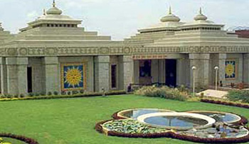
Satna district is proud to have two major religious tourist places of Chitrakoot & Maihar. Satna District is also proud to have an ancient city of Buddhist culture named `Bharhut`, whose archeological remains have been gifted to the major museums in the country and the world. Tulsi museum at Ram Van has many unique artistic sculptures of ancient times found in this area. Lord Shiva Temple at Birsinghpur is also a famous and old temple in the region Including the main festivals like other cities of India, Satna District has few festivals which are part of Madhya Pradesh culture. Festivals like Kali dasa festival, Nimar Utsav, Tansen samaroh, Lok Rangan festival, Lok rang Festivals are the important one. Satna district lies on Vindhyan Plateau, which has an average altitude of 1000' to 11000'. The southern portion of Nagod Tehsil below 24"30' north latitude is a hilly country consisting of a tangled mass of low hills, and enclosing considerable stretches of level ground. The height of the plateau enclosed by these hills is from 1700' to 1800' generally but occasionally, some of the hills in the south of the tahsil rise to more than 800 feet in height above the plateau. The general slope of the country of the tehsil is towards the east, inclined towards the north in the centre of the tehsil. Satna, the important river of the tehsil rises from the Panna hills and flows east as long as it is in Nagod tehsil. Near village Kathkone in Nagod Tehsil it is joined by the Amran river, and from this point of junction, it bends towards the south, making the boundary of Nagod and Raghuraj Nagar tehsils, till it meets the Tons river a few miles to the south-east of Satna town. Barua is another river of some importance in the tehsil, which rises from the hills in the south of the tehsil and flowing almost due west joins the Tons a few miles below village Karaia, at the border of Maihar and Nagod tehsils. Satna being on the important railway route is the goods-transport capital of the Vindhya region as most of the trade supplies to the region are unloaded and further supplied to other Vindhya regions from here. Trade routes From Utter Pradesh to Vindhya region are exclusive to Satna and Rewa, but since Rewa is not well connected by rail lines so Satna takes benefit of the fact and is prime trade location and houses big traders. Amarpatan Tehsil is bounded on the south by the Son river. The Kaimur ridge, with its scarp side to the south, rises suddenly like a wall about eight miles to the north of Son river, going towards the east, with slight northerly inclination, almost parallel to the Son river. North of Ram Nagar, an isolated small hill rises to 2,354'. Rest of Amarpatan tehsil is again an alluvial plain draned by the Behar river, which flows more or less parallel to the Mirzapur road, in a north-easternly direction. Currently the economy is on the boom in here. Satna is in the transient stage of transformation to a big city. As the city takes the trade hub stature, it follows a high intake of people immigrating from other regions to it and subsequent increase in the demand of goods and services need to be fulfilled, therefore a boom of companies in the areas of banking, commerce and trade, and consumer goods (brands with big name) are increasingly registering their presence in the region. Tha Kaimurs, the Panna hills, and the Vindhyachal ranges, all belonging to the Vindhya system togeter with their spurs constitute the principal hills of the district. The Kaumur range enters Maihar tahsil of the district at village Jhukehi on the border of Murwara tehsil, and runs through the entire length of Maihar and Amarpatan tahsil in an easterly direction slightly inclined to the north. At Jhukehi, the strike of the Kaumurs is displaced, producing the only gap in the whole length of the Vindhyas. Advantage of the gap is taken in the construction of the Mirzapur road and the Jabalpur-Allahabad section of Bombay -Calcutta railway line. The Panna hills enter northern portion of the district from Panna district and traverse the Raghuraj Nagar tehsil in a west-east direction and enter the Sirmour tehsil of Rewa district. The Vindhyachal range is in the extreme north of the district cutting across in a west-east direction slightly inclinedc to the north. Tons (or Tamasa) is the main river of the district, It rises in the Kaumur hill in the Maihar tehsil, its nominal source, called Tamasa Kund being a tank on the Kaumur hills, 2,000 feet above the sea-level. From the point is follows a general north-easterly course, traversing the rough hilly country around Maihar, flowing through the level fertile country of the Amarpatan and Raghuraj Nagar tehsil, and then enters the Rewa district. Satna an important affuent of the Tons, rises in the Panna hills, flows through the northern, narrower portion of the Nagod tehsil almost in a due west-east direction and bends towards the south from the point where it is joined by Aman river. Thereafter it makes the boundary of the Nagod and Raghuraj Nagar tehsils till it meets the Tons a few miles to the south-east of Satna town. Simrawal, another impurtant affluent of the Tons, flows south of Kothi in Raghuraj Nagar tehsil. Raghuraj Nagar tehsil consists in the south of an alluvial plain watered by the Tons and its tributaries the Satna, and the Simrawal from the north-west and the Magardha and Nar from the south. The Panna hills cross the narrowest portion of the tehsil in a west-east direction slightly inclined to the north and separate the valley of the Paisuni, in part ravinous, from the plateau to the south. Further north is Vindhyachal range running from west to east, almost parallet to the Panna hills, through the former sanad states of Baraundha, Patharkachhar and the Chaube jagirs Forest in the district are included in the Rewa forest division with headquarters at Rewa. Forests, which are mostly mixed forests cover an area of 900 square miles in the district, extending over four ranges with headquarters at Satna, Majhgawan (both in Raghuraj Nagar tehsil) Nagod and Maihar. The breakup of the forests according to whether they are protected or reserved forests is given below for each range. The Son, the great river to the south of the Kymore hills does not actually enter the district but makes the southern boundary of Amarpatan tehsil with Beohari tehsil of shahdol district. It is joined by the Mahanadi river, which flows along the boundary of Maihar and Beohari tehsils just at the point where the Son takes a turn towards the east between villages Sakwari and Bamaraha. Satna is also famous for scenic temples. One of those temples, named "Venktesh Mandir", is situated near Mukhtyarganj. It was constructed between 1876 - 1925 by the royal family of Deorajnagar. Dali Baba is a very ancient place of worship of satna,said to be established in 1857 by Abdaldas Baba. Jain temple was constructed in 1880 and Pranami Mandir in 1890.A new temple named "Pashupati Nath" has been also built recently on the outskirts of Satna.There are temples of Saibaba, located at Dhawari and Sindhi colony where hundreds of people gather every Thursday for worship. One more famous temple is "Shiv temple" on the bank of Jagatdev Talab, a man made water reservoir. Around Satna Khajuraho, Ramvan, Chitrakoot and world famous temple of Maa Sharda is in Maihar which is a sub-town of Satna.there are also hanuman statue near ramban 16 k.m.away from satna city at rewa road. |
How to reach Sagar? |
|
Nearest Railway Station: Satna is well connected by Train as well as by Bus route through Bombay-Hawarah Train route and National Highway No.7 through Maihar-Amarpatan & State Highway Chhatarpur-Rewa respectively. Satna Junction railway station (IRCTC code STA) is a prominent station in Madhya-northern railway division on the route between Jabalpur Junction and Allahabad. It is a junction and the branch goes to Rewa from here. The railway station has three platforms with all up going trains (trains in the direction of Mumbai) coming normally on platform number 1 and all down going (trains in direction of Allahabad-Manikpur) coming in platforms 2 and 3. |
|
Nearest Airport: The main Airport is Satna Airport which is under development while the next near airport is Khajuraho Airport which is approximately 120 kilometres from Satna connected through Chhatarpur-Satna Road. Satna has its own smaller airport called Satna Airport but there are no regular flights using this airport right now.The nearest Airport is at Khajuraho which is approximately 130 kilometres from Satna connected through Chhatarpur- Satna Road. |
|
Road Transport: A couple of state highways and a national highway make it well connected by roads too. Satna is connected to the longest National Highway: NH-7. NH-75 passes from the heart of the Satna city and connects the cities of Panna and Rewa which are other important cities of northern Madhya Pradesh state of India. |
Tourist Attraction of Satna: |
|
Satna district is proud to have two major religous tourist places of Chitrakoot & Maihar. Satna District is also proud to have an ancient city of Buddhist culture named 'Bharhut', whose archeological remains have been gifted to the major museums in the country and the world . Tulsi museum at Ram Van has many unique artistic sculptures of ancient times found in this area. Lord Shiva Temple at Birsinghpur is also a famous and old temple in the region . Chitakoot Dham: Chitrakoot incorporates very many places of religious and pauranic importance,visited both by devotees and sight-seers.From the administrative view point, some of these places are situated in Uttar Pradesh and others in Madhya Pradesh. As all these places are popularly associated with religious feelings of the people and a large number of pilgrims visit these sites. It is well connected by train as well as by road. The distance from Satna district headquarter is 60 Km. Approx. Ma Sharda,Maihar: Maihar has a temple by the name of Sharda Devi situated on the top of a hill about 5 km from the center of the town. This temple is known for its stairway of more than 1,000 steps. Millions of devotees throng to the temple throughout the year. Goddess Sharada is also called Saraswati. She is the Goddess of learning. She provides intelligence, mind, wisdom and logic. She helps to fulfill one's desire in life by the dint of her power of knowledge. The Holy Maa Sharda Temple is situated in Village Maiher of Satna District InMadhya Pradesh. The place is well connected by road and train route. The approximate distance from Satna district headquarter is 40 Kms. The temple is situated on the Trikut mountain at a height of 600 ft from ground level. To reach the shrine one has to climb 1001 stairs. The temple is managed by Maa Sharda Prabhand Samiti. The committee, headed by district collector, has done significant work to enable better facilities to pilgrims and devotees visiting the temple from all over the country. Road route is constructed on the mountain so that the vehicle can be taken upto the hill top. Shiv Temple, Birsinghpur: Lord Shiva Temple at Birsinghpur is also a famous and old temple in the region. To have Darshan and offer prayers in the famous temple of Birsinghpur, the devotees can reach by road from Satna. Griddhraj Parvat: Griddhraj Parvatis a hill of religious, archeological and ecological importance situated in Devrajnagar village of tehsil Ramnagar in Satna district. It is located 8 km from the town of Ramnagar. Griddhraj Parvat is of great religious importance in Hindu mythology .It was mentioned in Skanda Purana as `Griddhanchal Parvat`. It is believed to be the birthplace of `Sampati` , the brother of Griddhraj `Jatayu` mentioned in Ramayana. The poet Kalidas mentions this place as the most sacred in his book `Griddharaj Mahatmya` (Narad Uvach). He wrote that a dip in the Manasi Ganga River originating from Griddhraj Parvat, at an altitude of 2,354 feet, absolves all kinds of sins. Sons of Brahma and then goddess Parvati first saw this hill. It is also mentioned in Shiva Samhita Chinese traveller Fa-hien visited this place and mentioned it. Bharut: Bharut is an ancient city of Buddhist culture, whose archeological treasures have been gifted to the major museums in the country and the world. The Bharhut stupa may have been established by the Maurya king Asoka in the 3rd century BCE, but many works of art were apparently added during the Sunga period, with many friezes from the 2nd century BCE. The other important visiting places of Satna district are 1. Tulsi museum at Ram Van, which has many unique artistic sculptures of ancient times found in this area. 2. Lord ShivaTemple is also a famous and old temple in the region.chhota sthan sohawal is beautiful temple of god ram and sita.which is situated at sohawal 7km far from satna in panna road` . |
Hotels/Lodge/Accommodation in Satna: |
| bharhut hotel,Uma residency hotel. |
.jpg)
.jpg)
.jpg)
.jpg)