
Anuppur |
About: |
|
Anuppur is an administrative district of Madhya Pradesh state in central India. The district has an area of 3701 sq km, and a population of 667,155 (2001 Census). 309,624 people are from scheduled tribes and 48,376 are scheduled castes. The District is bordered by Koriya District of Chattisgarh state on the east, Bilaspur District of Chattisgarh on the southeast, Dindori District of Madhya Pradesh on the southwest, Umaria District of Madhya Pradesh on the west, and Shahdol District on the northwest and north. The administrative headquarters of the district is Anuppur. The District was created on 15 August 2003 out of Shahdol District. It is part of Rewa Division. Anuppur District is mostly hilly and forested. The Narmada River originates from the hill of Amarkantak in the Maikal Hills, and the Son River originates nearby. District Anuppur is divided into 4 tehsils, 04 janpads and 277 Gram Panchayats, There are 02 Municipalities and 04 Nagar Panchayats. Annupur is a sought after destination for a nature lover, pilgrim and an adventure seeker. Anuppur district is a tribal dominated district in the state of Madhya Pradesh, which forms a part of the central India. Anuppur City is blessed with two important & Beautiful Rivers i.e. Son & Tipan. |
Location info: |
| Anuppur is located at 23.1°N 81.68°E. It has an average elevation of 505 metres (1656 feet). |
Climate/Weather of Anuppur : |
| The climate of Annupur is temperate. It rains from June to October in the district. The temperature remains the highest in the month of June and the lowest in the month of January. The maximum and minimum temperatures of the district are 46 degree C and 2.6 degree C. |
Educational Institutions of Anuppur : |
| ST JOSEPH'S MISSION SCHOOL Yuva Kalvan Avam Naveen Educational Society College |
Langauge |
| The predominant language of the region is Hindi. Due to the rule of Marathas, Marathi is spoken by a substantial number of people. |
Culture: |
|
Annupur is a tribal dominated district. Their living standard is very simple. They live in houses that are made of mud, bamboo sticks, paddy straw and local tiles. The tribes wear dhoti, bandi, fatohi and headgear. The tribal women wear saree (kaansh saree). The saree they usually wear is body colored. They prefer painting their body parts hands, legs and neck. They wear different kinds of ornaments made of bamboo, seeds and metals. The district is very rich in mineral resources as coal, bauxite and fire clay. Most of the coalmines are located in Kotma Sub Division. As per the 1998 Survey, there are 106 industries ( Large Scale & Small Scale ) in the whole District. The Orient paper Mill and Soda Factory are situated in Amlai. Small Scale industries of polythene and Baskets of Bamboo are also run in the District. There is a Bidi Factory in Venkatnagar. 94% villages of the District have been electrified. One third of the district is under forest cover and agricultural productivity is the region is low as a result of less availability of water. Occasionally, wheat & gram are cultivated where there is soil-moisture available. The main trees found in the district are sal, amla, teak, sarai and shisham. The mahua and guli flowers in the forests provide the people with edible oil. Tribal people mostly use Mahua flower for making wine. The government of Madhya Pradesh is looking forward for developing land and water resources and also providing training for farmers in adequate agricultural practices. According to the census of 2001, the population of the Anuppur district is 667,155 out of which 309624 are scheduled tribes and 48376 are scheduled castes. It is because of the huge tribal population that Anuppur district is also known as a tribal dominated district. The total literacy percentage of this district is 57.76%, which is less than that of the national literacy percentage recorded as 59%. Anuppur district consists of a series of mountain ranges and rivers and can be subdivided into three geographical divisions namely, High lands of mountain ranges, Low lands of rivers and the Central plateau. Anuppur district is also rich with mineral deposits — the region of Amarkantak, in particular, is famous for its large deposits of bauxite. Other minerals include coal and fire clay, with most of the coalmines located in the Kotma subdivision. The rivers that flow through the district are Son, Johila, Narmada, Tipan, Bakan, Chandas and Kewai. |
How to reach? |
| Nearest Railway Station:Railway facilities are also available for Katni, Chirimiri and Bilaspur route. It is also well connected with all the metros of the Indian subcontinent. |
| Nearest Airport:Flights fromDelhi, Nagpur, Mumbai, Khajuraho and Bhopal to Raipur. |
| Road Transport:Reaching the Anuppur district does not involve much hassle. Road is the main means of transportation as the Matelic Road and the Kachhi Road is at a short distance. |
Tourist Attraction of Anuppur : |
|
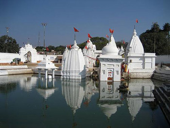
NarmadaMandir Narmada Mandir is a group of temples. Amarkantak: a source of invaluable Jadi-Butis: The forests surrounding Amarkantak are home to various invaluable medicinal plants like brahmi, gulbakawali, safedmusli, kalimusli, tejraj, bhojraj, patalkumhna, kali haldi, devraj, hatahjodi, jatashankari, ashta gandha. At present the local vaids use them to make herbal remedies, some of which are well known for their potency. Narmada Mandir (group of temples): Narmdeshwar temple which has a holy kund made at the source of river Narmada is the most important temple at Amarkantak. There are about twenty small temples in the premises of the Narmada Mandir each one of which is important in its own way. There is the Sati temple, which is, devoted to Parvati. The protected site of the ASI is close to the main Narmada temple . Mai Ka Bagiya: About one Km. from the main temple, there is a garden, which lies in a densely forested area. It is popularly believed that the Narmada devi used to pluck flowers in this garden. Bhrigumandal: It is around 3 Kms. from Amarkantak on a difficult forest trek route. It is believed that Bhrigu Rishi meditated here. The Parasvinayak and Chandi caves are on this route. Jwaleshwar Mahadev: The origin of river Johilla. There is a temple deep in the forest ofJwaleshwar Mahadev . There is a 'sunset point' close to this temple. At a distance of 8 Kms.from the origin of riverNarmada, the river falls from a height of 100 feet creating a waterfall known as Kapildhara. It is believed that the Kapil rishi meditated here. Dudhdhara: At a distance of 1 Km. from Kapildhara there is another beautiful waterfall on the river Narmada called Dudhdhara. Shambhudhara & Durgadhar: Two other extremely beautiful waterfalls are situated deep in the forest. One has to walk a few Kms. to see these breathtaking waterfalls. Sarvodya Jain Temple: This temple is under construction.It is considered a construction marvel. Cement and iron have not been used in this temple and the weight of the idol to be placed in the temple is around 24 Tones. |
Hotels/Lodge/Accommodation in Anuppur : |
| Hotel Mandakini Palace,mandakini plaza,hotel taj plaza, hotel yamuna view, |
.jpg)
.jpg)
.jpg)
.jpg)